
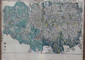
Tango Province (Shogun era; now northern part of Kyoto Prefecture)
by
Motonobu Aoo and Toshiro Eirakayu
Rare map of Settsu
Detail
Date of this map: ca. 1820
Dimensions (with margins): 32,9 x 26,3 cm
Condition: Very good. Original colouring. Strong woodcut print on Japanese rice paper on two sheets and clear image. Sufficient margins to frame.
Condition rating: A+
Verso: blank
From: Kokugun Zenzu (Atlas of Japan, deluxe version)
Price (without VAT, possibly to be added): €250,00 (FYI +/- $277,50 / £222,50)
Unless otherwise specifically stated on this map page, we charge the following expedition costs in euro (unfortunatelly, gone up with Covid, but still too low in reality!):
– Benelux: 40 euro
– Rest of Europe: 60 euro
– Rest of the World: 100 euro
In stock
Related items
-

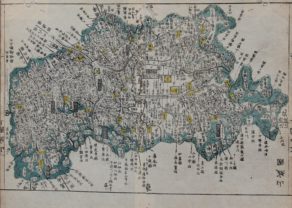
Yamato Province (Shogun era; now Nara Prefecture)
by Motonobu Aoo and Toshiro EirakayuPrice (without VAT, possibly to be added): €350,00 / $388,50 / £311,50Rare map of Yamato (Nara)
-
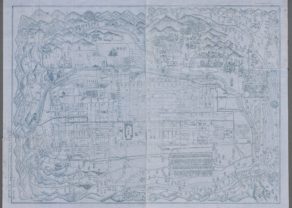
[Untitled] Kyoto by unknown Japanese mapmaker
by UnknownPrice (without VAT, possibly to be added): €1 250,00 / $1 387,50 / £1 112,50Simply unique: Very rare Japanese map of Kyoto in blue ink
-
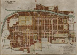
Kyoto – Kioto
by Kakuma YamamotoPrice (without VAT, possibly to be added): €800,00 / $888,00 / £712,00 -
Iga Province (Shogun era; now in Mie Prefecture)
by Motonobu Aoo and Toshiro EirakayuRare map of Iga
You may also be interested in:

Achaia, Attica and Gulf of Corinth
by
Johannes Janssonius
Price (without VAT, possibly to be added): €450,00 / $499,50 / £400,50

Chester – Cestria vulgo Chester, Angliae Civitas
by
Georg Braun and Frans Hogenberg
Price (without VAT, possibly to be added): €900,00 / $999,00 / £801,00

Portrait Abraham Ortelius, by Galle
by
Abraham Ortelius, Philip Galle
Price (without VAT, possibly to be added): €800,00 / $888,00 / £712,00

Scotland – Nova Scotia
by
Willem and Joan Blaeu
Price (without VAT, possibly to be added): €1 000,00 / $1 110,00 / £890,00
A nice map of Scotland
Tango
Tango Province (丹後国, Tango no Kuni) was a old Shogun province in the area that is today northern Kyoto Prefecture facing the Sea of Japan. So, North is bottom of map.
Maps of Japan and Tango Province were reformed in the 1870s when the prefecture system was introduced. At the same time, the province continued to exist for some purposes. For example, Tango is explicitly recognized in treaties in 1894 (a) between Japan and the United States and (b) between Japan and the United Kingdom.
Kokugun Zenzu
The Kokugun Zenzu was an atlas made under the Tokugawa shogunate and given as a present to the favorite warlords. It contains more than 70 regional maps of Japan and was compiled by Motonobu Aoo and Toshiro Eirakayu.
Ino Tadataka
Based on the work of Japanese master Ino Tadataka (11 February 1745 – 17 May 1818). He was a Japanese surveyor and cartographer. He is known for completing the first map of Japan using modern surveying techniques.
He surveyed Japan, a task, which consumed the 17 years of his life, covered the entire coastline and some of the interior of each of the Japanese home islands. During this period Inō reportedly spent 3,736 days making measurements (and traveled 34,913 kilometres), stopping regularly to present the Shogun with maps reflecting his survey’s progress. He produced detailed maps (some at a scale of 1:36,000, others at 1:216,000) of select parts of Japan, mostly in Kyushu and Hokkaido.