


Systema Mundi Tychonicum
Detail
Date of first edition: 1740
Date of this edition: 1740
Dimensions (not including margins): 49 x 57,6 cm
Dimensions (including margins): 54 x 62,2 cm
Condition: excellent. Sharp copper engraving on strong paper. Discrete old colouring. Centre fold as published.
Condition rating: A+
Verso: blank
From: Atlas coelestis
In stock
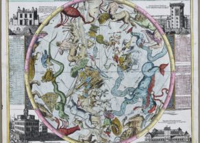
The Tychonic system of the World
A superbly decorative chart from the important Atlas Coelestis of Johann Gabriel (1677-1750) . The map represents the Tychonic system of the World, that Tycho Brahe introduced in 1577, in order to maintain the central position of Earth and to give an exact description of the celestial motions.
During the 18th century this model competed with the Copernican system and was accepted by catholic astronomers that censured Galileo.
The main diagram shows Brahe’s theory that the sun revolves around the earth and the other planets revolve around the sun. In the corners are smaller diagrams showing alternative theories for the movement and size of celestial bodies. The main diagram is surmounted by Apollo driving his chariot across the sky and surrounded by constellations/signs of the zodiac. The chart was drawn by the mathematician J.G. Dopelmayr and published by the Homann publishing firm.
Portraits of Tycho Brahe and Riccioli are in the upper portion of the chart with diagrams of their planetary systems delineated in each corner. The map is further embellished with banks of clouds containing putti using scientific instruments.
Related items
-

Map of the Moon – Tabula Selenographica in qua Lunarium
by Johann Gabriel DoppelmayrPrice (without VAT, possibly to be added): €3 500,00 / $3 885,00 / £3 115,00The unique and famous first comparative chart of the Moon (with double competing nomenclature) from which the names of many lunar features have been derived.
-
Hemisphaerium Coeli Australe
by Johann Gabriel DoppelmayrPrice (without VAT, possibly to be added): €1 400,00 / $1 554,00 / £1 246,00
You may also be interested in:

San Adrian (Navarre) – La Sierra de Sant Adrian en Biscaia

Lisbon

Cuzco (Inca capital)
Rare first edition (block destroyed by fire)
