


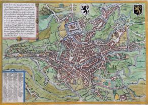
Brugge, Bruges, Brugae
First plate
Detail
Date of first edition: 1572
Date of this edition: 1582-1588: last line: “tamen… retinuerum”
Dimensions (not including margins): 31,5 x 46 cm
Dimensions (including margins): 41 x 55 cm
Condition: Very good. Sharp copper engraving printed on paper. Old coloured. Centre fold as published. Wide margins.
Condition rating: A+
Verso: text in Latin
Map reference: Van der Krogt, IV, 2-1, 660, page 16; Fauser, 2047 (makes no difference between the plates); Taschen, Br. Hog., p. 73; Arens 1997, p. 47f
From: Civitatis Urbis Terrarum, Liber primus, first published 1572. Van der Krogt IV, 2-1, 41:0
This item is sold
Brugge commented by Braun
“Bruges is said to have acquired its name from its great number of bridges. It has a marketplace adorned on all sides by magnificent houses, from which six wide streets lead away to the city gates. It has access to the sea, which lies three miles away; numerous streams and navigable channels run through the city. In later times its wealth diminished, partly because the water receded but partly, too, because the Hanseatic merchants left the city.”
Translation of cartouche text (bottom left): Brugae, generally known as Bruck, is the most beautiful and elegant of all German cities in Flanders. The splendour and magnificence of the public and private buildings in this city surpass all imagination and description. It possesses the best ground plan imaginable – one that is circular. It is surrounded by a double moat filled with water. It was formerly a flourishing city of commerce.
Cartouche top centre: Bruges, the pride of the cities of Flanders.
Taschen on Brugge
The city of Bruges in western Flanders is shown in a plan-like bird’s-eye view from a northwesterly direction, ringed by numerous windmills. At the centre can be seen the market square with the cloth hall, a rectangular complex dating from the 13th century and incorporating a belfry. Diagonally to the right behind it, with its even taller tower, is the Gothic Onze-Lieve-Vrouwe church, burial place of Charles the Bold and Mary of Burgundy. In the 9th century; as a defence against the attacking Normans, Baldouin II the Bald built a fortress on the only bridge surviving from Roman times; it was this that probably gave the site its name. In the 12th century Bruges rose to become a major centre of European trade, after a flood left the city with direct access to the nearby North Sea. Bruges received its charter in 1128. As a centre of Flemish cloth production, towards 1200 Bruges began holding trade fairs, at which wool imported from England was also sold. The first stock exchange was born at the inn run by the van der Buerse family of merchants, who subsequently gave their name to the concept of the “bourse” itself. In the 15th century Bruges saw a flowering of the arts: major artists such as the Van Eyck brothers, Hans Memling and Gerard David lived and worked here.
Related items
-
Ypres – Ieper
by Georg Braun and Frans HogenbergPrice (without VAT, possibly to be added): €500,00 / $555,00 / £445,00Ypres, where poppies blow…
-
Gent – Gandavum
by Georg Braun and Frans HogenbergRare view of the city without any walls
-
Mechelen (Malines) – Machlinia
by Joan BlaeuPrice (without VAT, possibly to be added): €1 200,00 / $1 332,00 / £1 068,00ON HOLD -
Brussels, 1593
by Georg Braun and Frans HogenbergPrice (without VAT, possibly to be added): €1 600,00 / $1 776,00 / £1 424,00An invitation to actively discover the city’s jewels
You may also be interested in:

Bristol – Brightstowe, Vulgo; Quondam Venta, Florentissimum

Michiel de Ruyter, a super collection by Stoopendaal
Maybe the greatest admiral of all times

Toledo (Castile) – Toletum

Difference between first and second plates
The first plate was published from 1572; the second edition from 1612 onwards.
The difference is easily discoverable:
The first plate: the first line in the cartouche left reads: “BRUGAE, vulgo Bruck Teuto:”
The second plate: the first line in the cartouche left reads: “BRUGAE, vulgo Bruck”. See our map 28000.