


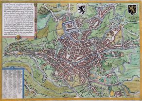
Gent – Gandavum vulgo Gent
by
Joan Blaeu
ON HOLD
Detail
THIS ITEM IS ON HOLD.
Date of first edition: 1649
Date of this map: 1650
Dimensions (not including margins): 43 x 54 cm
Condition: Very good. Strong paper and wide margins. This map is framed (see final picture).
Condition rating: A+
Verso: text in Latin
From: Novum Ac Magnum Theatrum Urbium Belgicae, (= “Stedeboeck”) Amsterdam, J. Blaeu
Price (without VAT, possibly to be added): €2 500,00 (FYI +/- $2 775,00 / £2 225,00)
Unless otherwise specifically stated on this map page, we charge the following expedition costs in euro (unfortunatelly, gone up with Covid, but still too low in reality!):
– Benelux: 40 euro
– Rest of Europe: 60 euro
– Rest of the World: 100 euro
In stock
Related items
You may also be interested in:

Veere – Vere
by
Ludovico Guicciardini
Price (without VAT, possibly to be added): €420,00 / $466,20 / £373,80

Edinburgh
by
Georg Braun and Frans Hogenberg
Price (without VAT, possibly to be added): €1 700,00 / $1 887,00 / £1 513,00

[Untitled] Japan
by
Benedetto Bordone
Price (without VAT, possibly to be added): €2 800,00 / $3 108,00 / £2 492,00
Very rare: oldest map of Japan, and … based on Polo’s description

Chart of the Gulf of Finland
by
Lucas Janszoon Waghenaer
History of a city
In 1537 Ghent refused a petition by the regent Mary of Hungary (1530-1555) in support of the wars of Emperor Charles V against France. On February 14, 1540 the emperor came with a large army to Ghent to precipitate this revolt. After he succeeded, he forced the nobles of the city to walk barefoot in front him with a noose around their necks. Since then called Ghent sling carriers.
For this map it is interesting to notice that the ramparts of the town which been demolished by the emperor as a sign of humiliation, have been rebuilt. The debris of the walls was reused for the construction of the so-called Spanjaardkasteel (castle of the Spanish; top center). This was a part of the former St Bavo’s Abbey and the so-called Saint Bavo Village. The castle was finished in 1545 and accommodated 2,000 men.
In the forthcoming war Ghent will repeatedly set the stage for events and battles:
This plate was first published by A. Sanderus in his Flandria Illustrata in 1641-44. When Blaeu published his City atlas of the Netherlands in 1649, he used the same plates.