


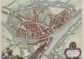
Liège – Leodium
Rare view of the city without any walls
Detail
Date of first edition: 1572
Date of this map: 1577
Dimensions (not including margins): 32,5 x 47,5 cm
Condition: Excellent. Strong image with lovely old original colours and wide margins. On heavy paper. Some minor browning, foxing in margins.
Condition rating: A+
Verso: text in Latin
Map reference: Taschen, Br. Hog., p. 65
From: Civitates Orbis Terrarum, Liber primus
In stock
Liège commented by Braun (on verso)
“There are many cities that are blessed by the Lord in different ways and are praised by all, some for their grain, others for their wine, their iron or copper, others for their beautiful and magnificent city walls and houses, others again for their favourable location on navigable rivers. But Liège surpasses all these cities, for the Lord God has furnished it with all the aforementioned virtues together […]. I must say as much as possible about the River Meuse, however, for it is not only the city’s greatest jewel but also its greatest asset, for of what use to a city are its own riches if it cannot exchange them for other vital necessities from other lands in a sensible manner?”
TRANSLATION OF CARTOUCHE TEXT LEFT: The origins of Liège (Lat. Augusta Eburonum) are traced by Hubertus Thomas Leodius back to Ambiorix, the magnanimous king of the Eburones […]. There are eight colleges of canons, four splendid abbeys, 32 parish churches, numerous monasteries and nunneries, for which reason Francesco Petrarch has observed that Liège is noted for its clergy. To the south lies a large forest, to the north fertile pastures with vines and fruit and the other necessities of life, watered by clear and lovely streams. The liberal arts are also prized here; no less than nine young kings, 23 dukes, 29 counts and many barons and the children of the nobility have been educated here.
The middle cartouche expresses thanks to the bisshop of Liège, Gerhard von Groesbeck, who provided the original on which the illustration was based.
Taschen on Liège
The magnificently designed engraving of Liège takes up the rapturous tone of Braun’s description and shows the city with the Meuse flowing in its favourable location amongst gentle hills, sturdy trees and fertile fields. Presented in spatial depth and exuding a striking sense of animation, it is one of the most successful landscapes in Braun and Hogenberg’s city atlas.
In 1468 Liège was attacked by Charles the Bold and set alight, profoundly altering the medieval face of the city. From the second half of the 15th century onwards much of the city was rebuilt in the contemporary style. The illustration shows the Ourthe flowing into the Meuse and the concentration of buildings in the city centre with its soaring churches and hospices. The cathedral of Saint-Lambert (20), which would later be destroyed in the upheaval of the French Revolution, is impressively documented. The Gothic collegiate church of Saint-Paul (26, centre right) was made Liège’s new cathedral. Examples of Romanesque architecture include the collegiate churches of Saint-Denis (right, 28), Saint-Barthélemy (32) and the church of Saint-Martin (far left), which was built in the Gothic style in the early 16th century.
Related items
You may also be interested in:

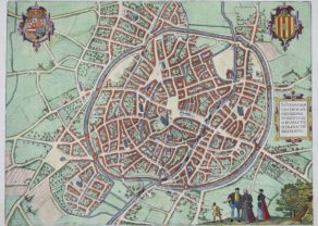
Edinburgh

Chart of the Gulf of Finland

China, Tartary and Japan
The first modern map of China printed in Europe

Leodium, city of the free people
This magnificent and very desirable hilly view shows the city of Liège from the South, where the rivers Meuse and Ourthe converge. The Prince-Bishopric of Liège was a state of the Holy Roman Empire in the Low Countries, situated for the most part in present Belgium, which was ruled by a prince, namely, the Bishop of Liège.
The old center was dominated by the former cathedral Saint-Lambert and the adjacent palace of the Prince-Bishop (see engraving).
Unfortunately, the cathedral (number 20; middle left with two identical towers) was destroyed in the upheaval of the French revolution. Today a central square (the place Saint-Lambert) has been built on the same spot. The palace of the Prince-Bishops (Palais des Princes-Evêques) has survived and currently serves as courthouse. At the left of this view, the Benedictine abbey of Saint- Laurent thrones. This abbey was mainly destroyed during the Eighty Year’s War. Saint-Laurent has only survived as a name for one of the quarter of the town. The city’s coat of arms (top right) shows a column above a fountain, called the Perron (see picture). This monument represents the freedom of the people of Liege. In its current form it was constructed in 1305. However, its origin goes back several centuries before then.
The origin of the name Leodium may go back to the Merovignian period (5th century – 8th century) meaning free people.
Although Liège is currently not the governmental capital of Wallonia (a region in Belgium), it may be considered as its cultural capital. Approximately 600.000 people live in its metropolitan area.