


Delfshaven
by
Joan Blaeu
Detail
Date of first edition: 1649
Date of this map: 1649
Dimensions (not including margins): 15 x 22,5 cm
Condition: Very good. Old colour. Strong print and clear image.
Condition rating: A+
Verso: text in Dutch (about Vlaardingen)
From: Toonneel der Steden van ‘s Konings Nederlanden, Met hare Beschrijvingen, (…) (Stedeboeck)
Price (without VAT, possibly to be added): €150,00 (FYI +/- $166,50 / £133,50)
Unless otherwise specifically stated on this map page, we charge the following expedition costs in euro (unfortunatelly, gone up with Covid, but still too low in reality!):
– Benelux: 40 euro
– Rest of Europe: 60 euro
– Rest of the World: 100 euro
In stock
Related items
-
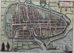
Rotterdam – Roterodamum
by Georg Braun and Frans HogenbergPrice (without VAT, possibly to be added): €840,00 / $932,40 / £747,60Origin of a world class port
-

Veere – Vere
by Ludovico GuicciardiniPrice (without VAT, possibly to be added): €420,00 / $466,20 / £373,80 -
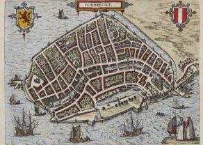
Dordrecht
by Ludovico GuicciardiniPrice (without VAT, possibly to be added): €300,00 / $333,00 / £267,00
You may also be interested in:

Bristol – Brightstowe, Vulgo; Quondam Venta, Florentissimum
by
Georg Braun and Frans Hogenberg
Price (without VAT, possibly to be added): €900,00 / $999,00 / £801,00

Achaia, Attica and Gulf of Corinth
by
Johannes Janssonius
Price (without VAT, possibly to be added): €450,00 / $499,50 / £400,50

Michiel de Ruyter, a super collection by Stoopendaal
by
Daniël Stoopendaal
Maybe the greatest admiral of all times

Chart of the Gulf of Finland
by
Lucas Janszoon Waghenaer
Delfshaven and Rotterdam
Up until the sixteenth century, Rotterdam was but a minor fishing harbor; Dordrecht (q.v.) was still the chief port of the graafschap of Holland. Between 1340 and 1348, Rottedam improved its connections to the inland reaches of the Rotte and Schie rivers by building a canal linking it to Overschie. This speeded the transport of raw wool for the draperies at ‘s-Gravenhage (q.v.) and Leiden (q.v.) to the advantage of Rotterdam as entrepôt. In 1389, Delft, to the northeast, built a small port at nearby Delfshaven, which is now part of Rotterdam. Rotterdam prospered still further when the harbor at Delfshaven began to silt up. By 1600, Rotterdam was the foremost port of Holland
Today, the port of Delfshaven is only used as a marina: