


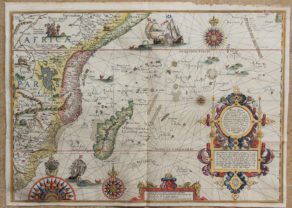
Ascension
by
Jan Huygen van Linschoten
Detail
Date of first edition: 1596
Date of this map: 1596
Dimensions (not including margins): 23,5 x 35 cm
Dimensions (including margins): 29,5 x 35,5 cm
Condition: very good. Sharp copper engraving. Sufficient margins, with right margin reinforced.
Condition rating: A
From: Itinerario
Price (without VAT, possibly to be added): €650,00 (FYI +/- $721,50 / £578,50)
Unless otherwise specifically stated on this map page, we charge the following expedition costs in euro (unfortunatelly, gone up with Covid, but still too low in reality!):
– Benelux: 40 euro
– Rest of Europe: 60 euro
– Rest of the World: 100 euro
In stock
Related items
You may also be interested in:

Bristol – Brightstowe, Vulgo; Quondam Venta, Florentissimum
by
Georg Braun and Frans Hogenberg
Price (without VAT, possibly to be added): €900,00 / $999,00 / £801,00

Map of the Moon – Tabula Selenographica in qua Lunarium
by
Johann Gabriel Doppelmayr
Price (without VAT, possibly to be added): €3 500,00 / $3 885,00 / £3 115,00
The unique and famous first comparative chart of the Moon (with double competing nomenclature) from which the names of many lunar features have been derived.

Cuzco (Inca capital)
by
Giovanni Battista Ramusio
Price (without VAT, possibly to be added): €850,00 / $943,50 / £756,50
Rare first edition (block destroyed by fire)

Achaia, Attica and Gulf of Corinth
by
Johannes Janssonius
Price (without VAT, possibly to be added): €450,00 / $499,50 / £400,50
Ascension, somewhere in-between
Jan Huygen van Linschoten (1563-1611) left the Netherlands for Spain in December 1593 to continue his training as a merchant. The commercial ambitions of this adventurous son of a public notary in Haarlem reached, however, much further than the borders of the Iberian peninsula. While pursuing his fortune he gained the confidence of the Archbishop of Goa, which made him the first Dutchman to get an impression of the gigantic colonial empire built by Portugal in the Far East. On his return to the Netherlands van Linschoten sold the story of his travels to the Amsterdam publisher Cornelis Claesz, who published it in 1596 in a book elaborately illustrated with maps and prints. The Itinerario is not only a travel story: apart from the tale of vn Linschoten’s wanderings on the Azores, in Portugal, and the present Indonesia two of his other works have been included, both dealing with navigation: ‘the Beschryvinghe van de gantsche custe van Guinea’ and the ‘Reys-gheschrift vande navigatien der Portugaloysers in Orienten’.
The significance of this first Dutch survey of the former Netherlands East Indies lies in the valuable sailing instructions which van Linschoten had managed to acquire, information that could only be found in the secret archives of the Portuguese administration. Abusing the trust put in him he had copied it page by page. Thus, in one step, the greatly coveted shipping route to the Netherlands East Indies and the route between the Asiatic sea ports as such, came within reach for Dutch navigators. Even more crucially,van Linschoten had also obtained information on very delicate nautical data that provided insight into the currents, deeps, islands and sandbanks, and such knowledge was absolutely vital for safe navigation. Additionally, everything was elucidated by coastal depictions and maps of unprecedented accuracy for those days. Dutch pilots had been preparing for the long voyage to the Far East for quite some time by research, study and practice. Since 1580 several foreign manuals, in which the technique of navigating the oceans was explained in full detail, had been translated into Dutch. Cartographic horizons had also been broadened. Within a period of scarcely ten years the nautical scope of Dutch navigators was improved almost to perfection and extended to the Mediterranean and the whole area between the Canaries and Russia. The publication of the ‘Itinerario’ in 1596 added the missing link to the research into itineraries and trade routes to the Indonesian Archipelago. A vast overseas trading empire was the immediate result.
Original title: Vera effigies et delineatio Insulae, Ascentcio nuncupatae…