


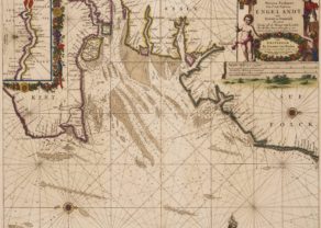
Eastern coast of England from Blakeney to Scarborough
Detail
Date of first edition: 1584
Date of this edition: ca. 1584
Dimensions (not including margins): 33,5 x 51 cm
Dimensions (including margins): 41,5 x 56,5 cm
Condition: Very good. Sharp copper engraving printed on strong paper. Nice colouring. Wide margins. Two tiny holes in top margin and two tiny holes in bottom margin (which have been repaired on verso). Back shows traces of previous framing.
Condition rating: A
Verso: text in Latin
From: Speculum nauticum (Spieghel der Zeevaerdt)
Waghenaer
The illustration depicts L. J. Waghenaer’s marine atlas, “The Mariner’s mirror”, published from 1584.
Lucas Janszoon Waghenaer was born in Holland in the 1530s. He became a famous ship pilot of his time. In 1584 he published the atlas (“Spieghel der Zeevaerdt”), which was greatly valued among mariners for centuries. This was not only because of its map content, but also because of a detailed knowledge of navigation techniques of that time. When it was translated from Dutch to English, the atlas appeared with a title page we are using on our home page.
Related items
You may also be interested in:

Chester – Cestria vulgo Chester, Angliae Civitas

Toledo (Castile) – Toletum

Chart of the Gulf of Finland

On this Map
This chart shows “Littus Septetrionale Angliae” or Noordt Custe va Engelandt”, more in particular the coast between Blakeney and Scarborough (Scharenburch). The mouth of River Humber is prominent in the centre of the map with the cities of Hull and Kingston.
Soundings, anchorages, and other navigational information appear in the North Sea. Place names and some nice topographical detail are shown along the coast. Three vessels decorate the sea. A 32-point compass rose orients the north to Soundings, anchorages, and other navigational information appear in the North Sea. Place names and some nice topographical detail are shown along the coast. Three vessels decorate the sea. A 32-point compass rose orients the north to bottom right. The title and distance scales are each enclosed by their own ornate cartouche. There is a profile view of the coast running across the top of the sheet. Waghenaer’s charts are renowned for their fine engraving by the best craftsmen of the period including Theodore de Bry and the Doetecum brothers. This map was engraved by Joannes Doetecum.
Description in the cartouche: Beschryuvinghe vandeHommer van Lint, Hull, Philo, ende Scherenborch met d’ontdiepen van dien.