


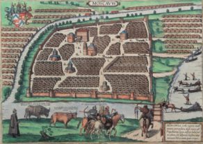
Moscou
Rare and beautiful
Detail
Date of first Blaeu edition: 1662
Date of this map: 1662
Dimensions copper plate (without margins): 38 x 48 cm
Dimensions (including margins): 56 x 64,6 cm
Condition: Very good. On strong paper with very wide margins. Original colouring.
Condition rating: A+
Verso: text in Latin
Map reference: Van der Krogt IV-2,1 2861
From: Atlas Maior, Van der Krogt IV-2,1 2:601, page 17
In stock
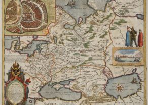
Moscou
This map was originally made by Hessel Gerritsz (1581-1632). In 1617 he was appointed the first official cartographer of the VOC, which brought him in a special position to collect unusual/unknown data. The map may have been published for the first time postmortem in 1642. Probably the map is derived from data collected under order of Boris Fyodorovich Godunov who ruled Russia from 1585 tot 1605.
The Kremlin takes a central position. It compasses the area between the Boulevard Ring and the Garden Ring in modern Moscou. The index mentions 60 locations.
Address to the reader: Benevole Lector, in hac tabula Urbis Moskuae….
Related items
-
Russia with Moscou (Blaeu after Gerritsz)
by Willem and Joan BlaeuPrice (without VAT, possibly to be added): €3 000,00 / $3 330,00 / £2 670,00From the very rare and unfinished Spanish edition of the Atlas Maior
-
Moscou
by Georg Braun and Frans HogenbergPrice (without VAT, possibly to be added): €2 100,00 / $2 331,00 / £1 869,00
You may also be interested in:

Asia Secunda pars Terrae in Forma Pegasi

Cuzco (Inca capital)
Rare first edition (block destroyed by fire)

[Untitled] Japan
Very rare: oldest map of Japan, and … based on Polo’s description
