


Russia and Moscou (Blaeu after Gerritsz)
Detail
Date of first edition: 1634 (Willem Blaeu)
Date of this edition: 1644-1650 (Joan Blaeu)
Dimensions (not including margins): 42,3 x 54,5 cm
Condition: excellent. Sharp copper engraving printed on paper. Repaired small tear (2 cm) in lower part center fold. Near to mint condition. Wide margins.
Condition rating: A
Verso: text in Spanish
Map reference: Van der Krogt 1800:2.2; Castner,II,p.52ff & fig.26.
From: Theatrum Orbis Terrarum; Van der Krogt 2:202-3
In stock
Blaeu and Russia
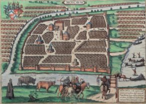
This map includes two insets: a plan of Moscow and a view of Archangel. The plan of Moscow is a reduced version of a Russian plan dating from approx. 1597-1599 and was probably copied by Fyodor Godunov as a school exercise. A note to the reader chiefly describes the fortifications of the city: “Gentle reader, here you see the sections of the walls of the city of Moscow divided into four, or rather the four fortifications of the walls, of which the innermost is called Kitaygorod and is also a city itself. Closest to this is the castle, or rather the palace, surrounded by walls, and called Kremlenagrad, which is encircled by two walls of stone, to which a few other materials have been added. The city, which continues to the east, north and west, is called Tsargorod, the city of the tsar: surrounded by walls of white stone but with earth added. The surrounding area outside is called Skorodum, with walls of wood but no earth; the part of it is situated on the other side of the Moskva River, however, is called Strelzka Slaboda, and soldiers live in the houses there, and the guard of the great lord the tsar and the grand duke, and other children of Mars.” The walls of Kitaygorod were built between 1534 and 1538. The nine-kilometer wall with 28 towers that surrounds Tsargrad, or Belgorod (white city), were built between 1583 and 1593. The outermost earthworks with a wooden wall was constructed in 1591. This part of the city was called Zemlyanoigorod (earthen city). In this earthen walls were 12 gates.
Related items
You may also be interested in:

Avignon
Papal city²

Luxembourg, Duchy

Edinburgh

Gerritsz and Russia
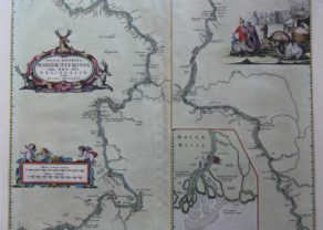
The full title of this map is: “Tabula Russiae ex autographo, quod delineandum curavit Foedor filius Tzaris Boris desums… – Domino regionum Iueriae Kartalinie et Groefiniae Tzari etc: dedicata ab Heselo Gerardo M.DC.XIIII”
A re-issue, by Willem Blaeu, of Hessel Gerritsz’ rare and influential map of Russia.Spanish text on verso, extending west to east from Emden to Aspachan and north to south from Langenos to Trapesus. This fine map was compiled from manuscripts brought back from Russia, by Isaac Massa to whom the large inset plan of Moscow is attributed.There is also a small view of Archangel. Russia’s only northern port until the founding of St Petersburg in 1700. Three figures in Russian dress stand above. The title is within a martial cartouche.
First issued 1613 and published by Blaeu after he acquired the plate following Gerritsz’s death in 1632. The top left corner has an inset plan of Moscow with a 17-point key.
The coat-of arms and the gun and sword carried by the person above the inset of Archangel heightened in gold.
The atlas Major was printed only in small numbers, the Spanish text edition is extremely rare. The Spanish edition was never completed. When fire destroyed the Blaeu printing house at the Gravenstraat in Amsterdam in 1672, the final volume was in the press and consequently lost.