


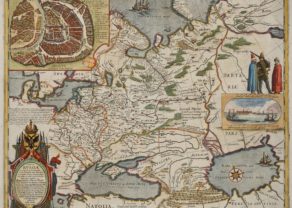
Volga River (Wolga) – Nova & Accurata Wolgae Fluminus…
by
Joan Blaeu
Detail
Date of first edition: 1662
Date of this map: 1664
Dimensions (without margins): 56 x 47,5 cm
Dimensions (including margins): 65,2 x 54,5 cm
Condition: Very good. On sturdy watermaked paper with wide margins. A crisp copper impression on a sheet with an Atlas watermark. Old colouring.
Condition rating: A
Verso: text in Dutch
Map reference: van der Krogt, 2, 1825:2
From: De Grooten Atlas (Atlas Maior); van der Krogt, 2:621
Price (without VAT, possibly to be added): €600,00 (FYI +/- $666,00 / £534,00)
Unless otherwise specifically stated on this map page, we charge the following expedition costs in euro (unfortunatelly, gone up with Covid, but still too low in reality!):
– Benelux: 40 euro
– Rest of Europe: 60 euro
– Rest of the World: 100 euro
In stock
Related items
-
Russia with Moscou (Blaeu after Gerritsz)
by Willem and Joan BlaeuPrice (without VAT, possibly to be added): €3 000,00 / $3 330,00 / £2 670,00From the very rare and unfinished Spanish edition of the Atlas Maior
-
Moscou
by Georg Braun and Frans HogenbergPrice (without VAT, possibly to be added): €2 100,00 / $2 331,00 / £1 869,00
You may also be interested in:

Antequera (Andalusia)
by
Georg Braun and Frans Hogenberg
Price (without VAT, possibly to be added): €475,00 / $527,25 / £422,75

Scotland – Nova Scotia
by
Willem and Joan Blaeu
Price (without VAT, possibly to be added): €1 000,00 / $1 110,00 / £890,00
A nice map of Scotland

[Untitled] Japan
by
Benedetto Bordone
Price (without VAT, possibly to be added): €2 800,00 / $3 108,00 / £2 492,00
Very rare: oldest map of Japan, and … based on Polo’s description

Veere – Vere
by
Ludovico Guicciardini
Price (without VAT, possibly to be added): €420,00 / $466,20 / £373,80
Blaeu, Olearius and the Volga
Uncommon map of the Volga River in two parts based on the travels of Adam Olearius. The left side of the map begins at Nazhniy Novgorod and ends at Saratov. The right side continues to Astrakhan with an inset of the river delta. Richly embellished with a strapwork title cartouche featuring reindeer, a scale cartouche with putti, and a fine pictorial scene of an encampment with camels. Dutch text on verso.
Adam Olearius was a German scholar, mathematician, geographer and librarian. He was sent in 1633 by Duke Frederick III to Moscow and Persia to seek treaties favoring the newly-founded city of Friedrichstadt as the terminus for an overland silk road. The party traveled from Hamburg to Moscow via Lubeck, Riga, Dorpat, Revel, Narva, Ladoga and Novgorod. A favorable treaty was struck with Michael Romanov in 1635. Later that year Olearius returned to Moscow and then on to Persia via the Volga and the Caspian Sea. After an arduous journey he met the shah in August 1637, but negotiations were not successful. On the return trip, Olearius left his party at Revel heading directly for Lubeck. He mapped the Volga along the way, bringing this knowledge to Europe.
The Volga (Wolga) is the longest river in Europe with 3,531 km (2,194 mi) length and a catchment area of 1,360,000 km². It is also Europe’s largest river in terms of discharge and drainage basin. The river flows through CentralRussia into the Caspian Sea. Major cities on this map are Kasan, Samara and Astrachan.