


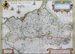
Northeast Germany – Tabula Electoratus Brandenburgici, Meckelenburgi et Maximae Partis Pomeraniae
by
Claes Janszoon Visscher
Rare and exceptional
Detail
Date of first edition: 1630
Date of this edition: 1630
Dimensions (not including margins): 45 x 54 cm
Dimensions (including margins): 48,7 x 57,5 cm
Condition: Excellent. Sharp copper engraving printed on paper. Centre fold as published. Age-toned. Old colouring. Good margins. Few professional repairs in margins.
Condition rating: A+
Verso: text in French
Map reference: Campbell, Claes Jansz. Visscher: A Hundred Maps Described (MCS No. 46), Nr. 18; Bott, 519
From: Appendix theatri A. Ortelii et Atlantis G. Mercatoris, 1631
Price (without VAT, possibly to be added): €3 200,00 (FYI +/- $3 552,00 / £2 848,00)
Unless otherwise specifically stated on this map page, we charge the following expedition costs in euro (unfortunatelly, gone up with Covid, but still too low in reality!):
– Benelux: 40 euro
– Rest of Europe: 60 euro
– Rest of the World: 100 euro
In stock
Visscher and Northeast Germany; carte-à-figures map of the electorate:
- Relief shown pictorially.
- With four inset views: Stetin, Stralsund, Rostock and Frankfurt on the Oder
- 2 bar scales on map, given in “Miliaria Germanica communia,” 9 units [= 4.85 cm]; and “Miliaria Gallica communia,” 12 units [= 4.85 cm].
- Decorative border, compass rose, rhumb lines, ships, vegetation.
- Pictorial vignettes of cities.
- Gothic script: Oost Zee.
- Appears in Blaeu’s Appendix theatri A. Ortelii et Atlantis G. Mercatoris, 1631.
Related items
-
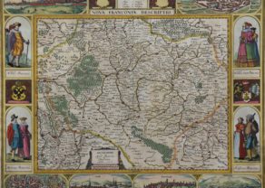
Franconia (Franken) – Nova Franconiae Descriptio
by Johannes JanssoniusPrice (without VAT, possibly to be added): €3 000,00 / $3 330,00 / £2 670,00Superb and rare carte-à-figures
-
Mecklenburg – Meklenburg ducatus, auctore Ioanne Laurenberg
by Willem and Joan BlaeuPrice (without VAT, possibly to be added): €320,00 / $355,20 / £284,80 -
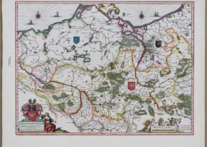
Brandenburg, Pommern, Mecklenburg
by Willem and Joan BlaeuPrice (without VAT, possibly to be added): €350,00 / $388,50 / £311,50
You may also be interested in:

Bristol – Brightstowe, Vulgo; Quondam Venta, Florentissimum
by
Georg Braun and Frans Hogenberg
Price (without VAT, possibly to be added): €900,00 / $999,00 / £801,00

Cuzco (Inca capital)
by
Giovanni Battista Ramusio
Price (without VAT, possibly to be added): €850,00 / $943,50 / £756,50
Rare first edition (block destroyed by fire)

Scotland – Nova Scotia
by
Willem and Joan Blaeu
Price (without VAT, possibly to be added): €1 000,00 / $1 110,00 / £890,00
A nice map of Scotland

Portrait Abraham Ortelius, by Galle
by
Philip Galle, Abraham Ortelius
Price (without VAT, possibly to be added): €800,00 / $888,00 / £712,00