")
")

Bosphorus – Anaplus Bosphori Tracii
by
Guillaume Sanson
Royal cartography: rare and spectacular
Detail
Date of first edition: 1666
Date of this map: 1666
Dimensions (not including margins): 41,3 x 53,3 cm
Dimensions (not including margins): 45,6 x 58,3 cm
Condition: Excellent. Strong paper and wide margins. Soft outlining old colouring.
Condition rating: A+
Verso: blank
Price (without VAT, possibly to be added): €1 100,00 (FYI +/- $1 221,00 / £979,00)
Unless otherwise specifically stated on this map page, we charge the following expedition costs in euro (unfortunatelly, gone up with Covid, but still too low in reality!):
– Benelux: 40 euro
– Rest of Europe: 60 euro
– Rest of the World: 100 euro
In stock
Related items
-
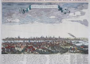
Constantinople (Istanbul) – Constantinopolis
by Seger TilemansPrice (without VAT, possibly to be added): €2 800,00 / $3 108,00 / £2 492,00Unique, rare and large frog’s view
-
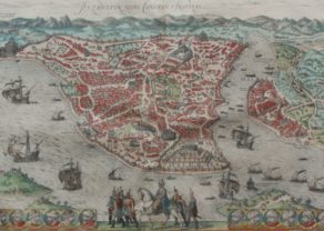
Constantinople (Istanbul)
by Georg Braun and Frans HogenbergPrice (without VAT, possibly to be added): €2 900,00 / $3 219,00 / £2 581,00This is the rare second state of the view, with the roundel at the right including the portrait of Sultan Murad III, which is blank in state 1.
-
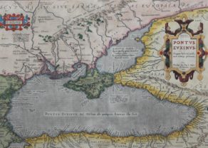
Black Sea in the Antiquity – Pontus Euxinus…
by Abraham OrteliusPrice (without VAT, possibly to be added): €1 000,00 / $1 110,00 / £890,00Where history never stops…
You may also be interested in:

San Adrian (Navarre) – La Sierra de Sant Adrian en Biscaia
by
Georg Braun and Frans Hogenberg
Price (without VAT, possibly to be added): €700,00 / $777,00 / £623,00

Asia Secunda pars Terrae in Forma Pegasi
by
Heinrich Bünting

Cuzco (Inca capital)
by
Giovanni Battista Ramusio
Price (without VAT, possibly to be added): €850,00 / $943,50 / £756,50
Rare first edition (block destroyed by fire)

Scotland – Nova Scotia
by
Willem and Joan Blaeu
Price (without VAT, possibly to be added): €1 000,00 / $1 110,00 / £890,00
A nice map of Scotland
The rise of French cartography
Starting in the fourth quarter of the 17th century Paris (and thus French cartography) will gradually start replacing Amsterdam as the central production site for mapmaking.
Nicolas Sanson (1600- 1667) is more or less regarded as the father of French cartography. He became chief cartographer under Louis XIV. One of his sons, Guillaume (1633-1703) will take over this position. The latter’s map of 1666 shows the Bosphorus Strait, with a length of 32 km between the Sea of Marmara to the south and the Black Sea in the north (Pontus Euxinus). The Bosphorus separates Europe from Asia. Bottom left in pink lies Constantinople.
The data for this map were provided by Pierre Gilles and go back to 1561.
Sanson mentions in the cartouche that he has obtained a privilege for 20 years to produce this map.