


Constantinopolis – Constantinopel
Superb double view
Detail
Date of first edition: ca. 1730
Date of this map: ca. 1730
Dimensions (not including margins): 49 x 56,5 cm
Dimensions (including margins): 53 x 64 cm
Condition: Very good. A crisp impression with contemporary color on strong paper. There was a small centerfold separation at bottom that has been closed on verso with paper tape. Wide margins. General slight age-toning.
Condition rating: A
Verso: blank
In stock
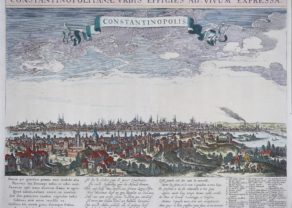
Constantinopolis with Bosphorus
This attractive sheet contains two maps of the city of Constantinople. At top is a bird’s-eye plan depicting the Golden Horn, the original Genoese district of Galata and the Bosphorus viewed from the village of Scutari. Extensive fortifications surround the city and many important buildings can be distinguished. Numerous galleons fill the Bosphorus with several warring ships. The bottom quarter of the sheet contains a finely rendered panorama of Constantinople viewed from the north, probably from the heights of Pera. A legend names and locates 30 important buildings, such as the Seraglio, Hagia Sophia, several mosques, and more. Dual titles in Latin and German.
Original title: Constantinopolis Amplissima, Potentissima, et Magnificentissima Urbs… / Constantinopel, die Grossest, Machtigst u. Prachtigste Residenz Stadt des Turck Kaysers…
Related items
-
Constantinople (Istanbul) – Constantinopolis
by Seger TilemansPrice (without VAT, possibly to be added): €2 800,00 / $3 108,00 / £2 492,00Unique, rare and large frog’s view
-
Bosphorus – Anaplus Bosphori Tracii
by Guillaume SansonPrice (without VAT, possibly to be added): €800,00 / $888,00 / £712,00Royal cartography: rare and spectacular
You may also be interested in:

Michiel de Ruyter, a super collection by Stoopendaal
Maybe the greatest admiral of all times

Toledo (Castile) – Toletum

[Untitled] Japan
Very rare: oldest map of Japan, and … based on Polo’s description

Matthäus Seutter
Matthäus Seutter (1678-1757) was a prominent German mapmaker in the mid-eighteenth century. Initially apprenticed to a brewer, he trained as an engraver under Johann Baptist Homann in Nuremburg before setting up shop in his native Augsburg. In 1727 he was granted the title Imperial Geographer. His most famous work is Atlas Novus Sive Tabulae Geographicae, published in two volumes ca. 1730, although the majority of his maps are based on earlier work by other cartographers like the Homanns, De L’Isles, and de Fer.
There are alternative spellings: Matthias Seutter, Mathaus Seutter, Matthaeus Seutter, Mattheus Seutter