


Cantino World Map, facsimile with commentary
Seminal map shown in a unique luxurious facsimile
Detail
Limited edition of 750: this is no 272
Original date of publication: 1502
Mapmaker: anonymous in Portugal
Date of the facsimile: 2004
Publisher of the facsimile: Il Bulino Edizioni d’arte, Modena
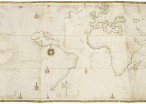
Dimensions: 105 x 220 cm in HD pics
Condition: new, printed on 6 sheets then stitched together, exactly like the original on 6 parchments stitched
Delivered in a specially developed box
Commentary book: by Ernesto Milano – director of the Este library (1977-2005); written in Italian with 8 pages abstract in English, 8 pages abstract in Spanish, 8 pages abstract in German
Commentary book: 128 pages, paperback 17 x 24 cm, ill. col., cardboard cover with flaps
Delivered with certificate of authenticity
This item is a nice complement to the facsimile of the Castiglioni World map.
This item is sold
Introduction
It is unanimously regarded as the most beautiful among Renaissance geographical maps and it bears witness to the discovery of America. It was manufactured and illuminated in Portugal in 1502, right after Columbus’ and Vespucci’s voyages. It is drawn on six sheets of vellum joined together to make up a single 105 × 220 cm sheet. It was probably commissioned by Italian ambassador Alberto Cantino (to Lisbon) to supply the Duke of Ferrara with documents showing the new dimensions of the world and the importance of the latest geographical discoveries. And so this Portuguese manuscript map arrived in Italy.
The planisphere shows the coasts of the Caribbean and Brazil (it is the most ancient representation representation of the New World in Italy), separated by the ‘raya’, the line that divided Portuguese colonies from the Spanish ones.
Even though it is one of the first maps that represent the world without applying the Ptolemaic tradition, Cantino’s Map is still influenced by it, with reference to some stereotypes to which even after Columbus’ discoveries is still entrusted, such as the Tower of Babel, the realm of Prester John or Eden. In spite of the definition charta del navicare, that is to say a map used for sailing, it is for sure a planisphere realized for court geography, to be studied and contemplated.
The original map is currently held at the Bibliotheca Estense in Modena.
Why is this world map so unique?
The Cantino map is the earliest surviving map showing the most recent discoveries of the Portuguese in Brazil, Newfoundland, Greenland, Africa and India. The arrival of several expeditions in 1502 brought a wealth of new information:
- April: Cabral from Brazil (this was the first European voyage to Brazil)
- 22 July: Coelho from Brazil
- 10 September: Vespucci from Brazil
- 11 September: da Nova: third expedition to India
- October: Corte Real from Newfoundland, labelled on the map as Terra del Rey de Portuguall
And Florida? If the peninsula drawn northwest of Cuba represented the coasts of Florida, it would mean it had been discovered 11 years before Ponce de León got credit for discovering it in 1513.
Also note the Tordesillas raya/line in blue (through Brazil), following the division of the world between an Spanish and Portuguese sphere of influence, based on the Treaty of Tordesillas of 1494.
Construction & Superb Illustrations
The Cantino planisphere is the earliest extant example of the so-called latitude chart, which was developed following the introduction of astronomical navigation, during the second half of the fifteenth century. Latitudes were incorporated only in the coasts of Africa, Brazil and India, while Europe and the Caribbean Sea continued to be represented according to the portolan-chart model.
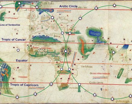
The illustrations are superbly elaborated. Two cities are grandly depicted – Venice and Jerusalem. There is also an elaborate depiction of the Portuguese castle of São Jorge da Mina (Elmina Castle on the Gold Coast of Africa, playing a key role in the slave trade), flanked by two African towns. Other illustrations include a lion-shaped mountain representing the Sierra Leone mountain range, the Alexandria lighthouse (laid horizontal), the mythical Mountains of the Moon (legendary source of the Nile River) in central Africa, and either the Table Mountain or Drakensberg range in South Africa. Along the central African coast are the various cross stone markers (padröes) erected by Diogo Cao and Bartolomeu Dias in the 1480s.
In north Africa, there is the “Montes Claros” in the usual place of the Atlas mountains, the legend below on the left reading that ‘this is the land of King Organo, whose king is very noble and very rich‘, and to the right that this is the ‘land of the King of Nubia, the king of which is continuously making war on Prester John and is a moor and a great enemy of Christians‘.
History
In short: the Cantino Planisphere is a copy from the Padrão Real. This was a cartographic work of Portuguese mastery produced secretly and maintained by the organization of the Portuguese Royal Court in the 16th century. The work was available to the scientific elite of the time, being exposed in the Casa da India. In the Padrão Real the new discoveries of the Portuguese were constantly added and mapped. The first Padrão Real was produced in the time of Henry the Navigator, even before the existence of the Casa da India. The Padrão Real of the House of India hung from the ceiling in the Division of Maps as the Portuguese masterpiece, extremely secretive and guarded of foreign spies and merchants. The Padrão Real included the complete record of the Portuguese discoveries, public and secret. The House of India issued maps based on the Padrão Real to navigators in Royal service. The Cantino planisphere 1502 is a copy of the Padrão Real, possibly produced by some Portuguese bribed cartographer. It is conjectured that Cantino was able to bribe a cartographer to copy the map between December 1501 and October 1502. From a letter signed by Cantino it is thought that he sent the map to the Duke of Ferrara on November 19, 1502. The Padrão Real was lost in time. However a copy Cantino planisphere still exists.
An Italian inscription it the back of the map reads: Carta de navigar per le Isole nouam trovate in le parte de India: dono Alberto Cantino al S. Duca Hercole, which translates as ‘Navigational chart of the islands recently [discovered]… in part of the Indies: from Alberto Cantino to Duke Hercole’.
In 1859 the palace of Modena, where the map was kept, was ransacked and the map got lost. Only seven years later it was found back… in a butcher’s shop by the director of the Biblioteca Estense where it is kept until today.
Unfortunately, strips of the parchment were cut off the top edge, removing part of the inscription of Greenland, and along the left edge, removing part of Columbus’s imagined Asia, the large landmass to the west of the Caribbean.
This limited facsimile edition
This unique edition of the Map, promoted by the Italian Ministry of Culture and presented by Laura Federzioni and Marco Cattini, is a joint-publication Il Bulino-Biblioteca Estense Universitaria. The facsimile has been printed in 5 fragments subsequently joined and lined together, presented in a special case (110 × 16 × 16 cm) together with the commentary volume by E.Milano and A.Battini and the certificate of authenticity.
This map is numbered 272 out of 750.
Pictures
Enjoy the following pictures:
1 World
2 Europe, Mediterranean, Middle East
3 British Isles and Iceland
4 Iberica
5 Venice
6 Jerusalem
7 Africa (notice the Pharos of Alexandria in Egypt)
8 Atlas Mountains
9 West Coast of Africa
10 South Africa with Mountains of the Moon and Table Mountain or Drankensberg
11Brazil
12 Cuba (and Florida?)
13 Asia
14 Slip case and commentary book
Related items
You may also be interested in:

Algiers – Algerii Saracenaorum Urbis Fortissimae…

Achaia, Attica and Gulf of Corinth

Luxembourg, Duchy
