


Castiglioni World Map, facsimile with commentary
Seminal map shown in a unique luxurious facsimile
Detail
Limited edition of 499: this is no. 331
Original date of publication: 1503
Mapmaker: probably Diogo Ribeiro
Date of the facsimile: 2001
Publisher of the facsimile: Il Bulino Edizioni d’arte, Modena
Dimensions: 81,5 x 214 cm in HD pics
Condition: new, printed on 6 sheets then stitched together, exactly like the original on 4 parchments stitched
Delivered in a specially developed box
Commentary book: by Ernesto Milano, Director of Biblioteca Estense 1977-2005 and by Annalisa Battini, Director of Biblioteca Estense 2015-2019; written in Italian
Commentary book: 128 pages, paperback 17 x 24 cm
Delivered with certificate of authenticity
This item is a nice complement to the facsimile of the Cantino world map.
This item is sold
Its origin & History
The Castiglioni Planisphere, which indicates the known world in 1525, is attributed to Portuguese Diogo Ribeiro, “piloto maior” (or leading mapmaker) of the Casa de Contratación in Seville – the office of the Spanish Crown established in 1503 and charged with representing new geographic discoveries on maps – and it is considered to be of exceptional interest as it is among the first to visually document the theories on the sphericity of the Earth.
In his earlier life Baldassare Castiglione (Mantua, 1478 – Toledo, 1529) was the Duke of Urbino’s ambassador to the court of King Henry VIII in England. Later he became the nuncio of Pope Clement VIII to the Court of Charles V in Spain. Thanks to his friendship with the emperor the latter presented this map as a gift to him. After his death his mother commissioned an inventory of the books and manuscripts he owned in Toledo, Castiglione’s place of death. The map remained the property of Counts Castiglioni until 2000 and it has always been stored at the family archives in Mantua. Baldassare Castiglione was also the author of the acclaimed work, the Cortegiano (The Book of the Courtier.
In summer 2000, the Italian State bought it and assigned it to the Biblioteca Estense in Modena, which was already home to a significant collection of maps. The world map has been placed in a specially made showcase and displayed in the ‘Campori’ room of the Estense Library, together with other important objects relating to the history of cartography, on the occasion of the event ‘Discovering the World. The Art of Cartography from Ptolemy to Mercator’ (January-May 2002). The Planisphere is now displayed on a panel and exhibited in the Giuseppe Campori room of the library.
The Castiglioni Planisphere has been the subject of an in-depth historical and scientific study (Ernesto Milano), complete with transcription and toponomastics (Annalisa Battini), published in the commentary to the reproduction sponsored by the Ministry of Culture, and curated by Roberto Bini through the coproduction by Il Bulino and the Biblioteca Estense Universitaria. There was a worldwide exclusive limited-edition of 499 numbered and certified copies.
Contents
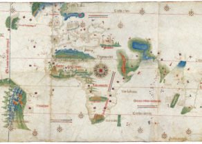
The map reflects the political and geographical situation of the first decades after the discovery of the New World. This map is characterized by high accuracy in the forms of the continents, including the Eastern coast of South America and the Caribbean. The accuracy in the depiction of Brazil is outstanding since that territory was first visited by Europeans only 25 years before the map was made. The map also shows the Tordesillas line as ‘Linea dela Particion’.
The mapping of South East Asia is even more remarkable since the world circumnavigation by Magellan’s expedition had just come back in 1522. The mapping of China is probably based on earlier land expeditions.
The recent expeditions to North America (except Florida) include:
- 1497: Italian navigator and explorer Giovanni Cboto (known in English as John Cabot) is credited with the discovery of continental North America on June 24, 1497, under the commission of Henry VII of England. Though the exact location of his discovery remains disputed, the Canadian and United Kingdom governments’ official position is that he landed on the island of Newfoundland. The English presence through Giovanni Caboto was signaled in Juan de la Cosa’s map of 1500
- 1499: Joao Fernandes Lavrador was licensed by the King of Manuel I of Portugal and together with Pero de Barcelos they reached Greenland and sighted Labrador for the first time since Leif Erikson, which was granted and named after Lavrador. After returning he possibly went to Bristol to sail in the name of England.
- between 1499 and 1502: the brothers Gaspar and Miguel Corte Real explored and named the coasts of Greenland, Labrador and also Newfoundland, naming “Terra Verde” the explored North American coasts. Both explorations were signaled in 1502 Cantino planisphere.
- 1524: Italian explorer Giovanni da Verrazzano sailed for King Francis I of France and is known as the first European since the Norse to explore the Atlantic coast of North America. Arriving near the Cape Fear River delta, he explored the coastlines of present-day states of South Carolina and North Carolina, entering the Pamlico Sound, and bypassing entrances to the Chesapeake Bay. Believing the New York Harbor to be a lake, he sailed past Long Island, exploring Narragansett Bay and Newfoundland.
- 1524–1525: Portuguese explorer Estevao Gomes, on behalf of Charles I of Spain (also known as Emperor Charles V), explored present-day Nova Scotia sailing South along the Maine coast. Gomes entered New< York Harbor and saw the Hudson River (which he named the “San Antonio River”).
Details of their voyages are fund back on this map.
According to the tradition of early modern nautical charts, the coastlines are marked with numerous place names, and the map combines Latin and Spanish inscriptions. The cities of Cairo and Jerusalem are prominently depicted, including the scene of the Crucifixion in Jerusalem.
Decoration
The coats of arms of Castile and León and Portugal are shown at the bottom of the planisphere, pointing out the division of the newly discovered parts of the world between both kingdoms after the Treaty of Tordesillas (1494). The decorative features of the map also include several wind roses and a large circular table of declinations representing zodiacal signs and the months of the years. At the lower left, we can see a horary quadrant, used to find the time of the day by measuring the Sun’s altitude. This element was a usual feature of Diogo Ribeiro’s maps.
Technical details
The Castiglioni World Map is a large nautical map drawn on four sheets of vellum (parchments) joined together to make up a single 81.5 × 214 cm (32.09 x 84.25 in) sheet. ‘Universal’ indicates the description of the whole then-known world, and ‘accurate’, the particular technical care employed by the cartographer. The map has been attributed to Diogo Ribeiro, head cartographer of the Casa de Contratación in Seville – the office of the Spanish crown authorized to compile innovations in official nautical maps deriving from discoveries. It is of great interest in that it is the first document of this kind to visualize the theories of the sphericity of the Earth.
An authoritative geographic map
The Castiglioni World Map is a perfect example of the official representation of the world after its circumnavigation by Magellan-Elcano in 1519-22. The Planisphere originated from an outstanding cultural milieu, producing maps destined to the control of trade with the Indies rather than to a popularization of geographic knowledge. The maps signed by Ribeiro, of which this one is among the oldest examples, referred to a prototype called ‘Padrón Real’.
Facsimile edition
The Castiglioni Planisphere has been thoroughly studied by Ernesto Milano in his historical essay – completed by a transcription and identification of geographical names by Annalisa Battini – which forms the commentary volume of the facsimile edition, produced under the patronage of the Italian Ministry of Culture. The work, edited by Roberto Bini, is a joint publication Il Bulino/Biblioteca Estense Universitaria. The facsimile, in the same size as the original, the commentary volume (17 × 24 cm), and the certificate of authenticity are presented in a case of 83 × 16 × 16 cm.
Exclusive worldwide printrun of 499 copies, each numbered and certified. The edition has been presented by Marco Cattini at the Estense Library in Modena.
This map is numbered 331 out of 499.
Pictures
Enjoy the following pictures:
1 Planisphere
2 Europe
3 Africa
4 India, South East Asia & China
5 Brazil until the Rio de la Plata and the flags of Spain and Portugal
6 North East America
7 Circular table of declinations representing zodiacal signs and the months of the years
8 Quadrant
9 Slipcase
10 Commentary book: cover
11 Commentary book: geographical overview of highlights
12 Commentary book: index of locations
Related items
You may also be interested in:

Chart of the Gulf of Finland

Veere – Vere

Achaia, Attica and Gulf of Corinth

China, Tartary and Japan
The first modern map of China printed in Europe