


Cuba Insula et Iamaica
Full of history
Detail
Date of first edition: 1597
Date of this map: 1597
Dimensions of the map (not including margins): 23,1 x 29 cm
Dimensions (including margins): 26,4 x 34,6 cm
Condition: Excellent. Sharp copper print on hard paper. Centre fold as published. Wide margins.
Condition rating: A+
Verso: blank
Map reference: Van der Krogt III,B 9610:371, page 10 (top right)
From: Descriptionis Ptolemaicae Augmentum; Van der Krogt, IIIB, 371:01-13
In stock
Columbus and Cuba
The name Cuba comes from the language of the Taíno. The exact meaning of the name is unclear, but it can be translated as “where the fertile soil is plentiful” or as “great place” (coabana).
On his maiden voyage, Columbus also visited the northeast coast of Cuba, where he landed on October 28, 1492. So Columbus landed first in Cuba and then on Hispaniola. On his second voyage he arrived there on April 30, 1494 and the island of Juana. He then explored the Southern coast – he assumed Cuba was a peninsula – and some small islands, including parts of the great Y. de Pinas, later known as La Evangelista and now Isla de la Juventud. In 1512, Diego Velázquez founded Cuéllar Baracoa, the first Spanish settlement on the island (seen on the east side). Havana was probably not founded until around 1519 and became the capital of this Spanish colony less than a century later, in 1607. Its name is derived from the Native American leader Habaguanex. In the southeast, a wide nameless bay opens up which is currently known as Guantanamo. Columbus traveled further into smaller Jamaica on his second voyage on May 5, 1494. The Taíno Indians called the island Xaymaca, land of forests and water. The first Spanish settlement here was Seville (top center), which reed was abandoned around 1524 because it was considered too unhealthy. Then in Oristan (now called Bluefields), where the Spaniards established a short-lived settlement in 1509, some crumbled walls remain. Riet in 1655 the English took over this colony from the Spaniards.
Related items
-
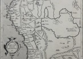
Peru – Peruani Regni descriptio
by Cornelius van WytflietPrice (without VAT, possibly to be added): €600,00 / $666,00 / £534,00 -
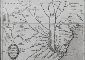
Rio de la Plata
by Cornelius van WytflietPrice (without VAT, possibly to be added): €500,00 / $555,00 / £445,00 -
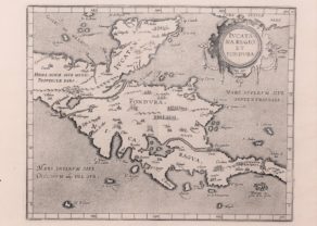
Iucatana regio et fondura
by Cornelius van WytflietFull of history
You may also be interested in:

Edinburgh

Veere – Vere

Scotland – Nova Scotia
A nice map of Scotland

Cornelius Wytfliet (? – 1597)
Cornelius Wytfliet was a geographer from Leuven. After graduating Licentiate in Laws from the University of Leuven, Wytfliet moved to Brussels and became secretary to the Council of Brabant.
In 1597 he published the first atlas of America: the Descriptionis Ptolemaicae Augmentum (Augmentation to Ptolemy’s description). He named his work an augmentation to Ptolemy’s Geography because it covers the Americas, a part of the world unknown to Ptolemy. However, there is no other connection between the works of Ptolemy and Van Wytfliet. Dedicated to Philip III of Spain it is a history of the New World to date, recording its discovery, natural history, etc. It provides a history of exploration and the voyages of Christopher Columbus (1492-1502), John Cabot (1497-98), Sebastian Cabot (1526-28), Francisco Pizarro (1527-35), Giovanni de Verazzano (1524), Jacques Cartier (1540-42), and Martin Frobisher (1576-78). Most of Van Wytfliet’s maps are the first or among the earliest of specific regions of North and South America.
For the book, Wytfliet had engraved nineteen maps, one of the world and eighteen regional maps of the Americas. The book was an immediate success and ran to several editions.
Two editions of the Descriptionis Ptolemaicae were published et Leuven in 1597 and 1598. In 1603 appeared the first Douai edition with later editions with French text. The last edition was published in Arnhem in 1615.