


Columbia, Panama and Venezuela
Full of history
Detail
Date of first edition: 1597
Date of this map: ca. 1597
Dimensions of the map (not including margins): 22,5 x 29,5 cm
Dimensions (including margins): 28,5 x 36,2 cm
Condition: Good. Sharp dark print. Centre fold as published. Wide margins.
Condition rating: A
Verso: blank
Map reference: Van der Krogt III,B 9810:371, page 7 (top right)
From: Descriptionis Ptolemaicae Augmentum; Van der Krogt, IIIB, 371:01-03
In stock
The Spanish treasure map
Nice example of Cornelis Wytfliet’s map of Colombia, Panama and Venezuela, one of the earliest obtainable maps of the region.
This map shows the wider region around Panama and Colombia, up to Ecuador. The C. de S. Francisco is located on the Ecuadorian coast. The expedition led by Alonso de Ojeda in 1499 visited the Venezuelan coast (Venesuela). Amerigo Vespucci was part of this voyage. The stilt houses in the Maracaibo lago reminded him of Venice and so he called this area Veneziola, which in his Tuscan native language meant “little Venice”. The current spelling is the result of the Spanish suffix -uela. Another explanation is given by Martín Fernández de Enciso, a fellow traveler at the time. He stated in his work Summa de Geografia that the local population called themselves Veneciuela. One of the most important cities was Panama, founded on August 15, 1519 by Pedro Arias Dávila and a departure point for the Spanish conquista to Peru. Darien is the current name of the Darien Gap, an impenetrable piece of jungle that never fully completed the Pan-American Highway between Prudhoe Bay in Alaska and Ushuaia in Argentina’s Tierra del Fuego.
Cartagena in modern-day Colombia was founded by Pedro de Heredia on June 1, 1533 and was the main port of departure for the Spanish treasure fleet. The title of this card Castila Aurifera refers to the silver treasures. Furthermore, one notices the Colombian cities of Buenaventura (founded on June 14, 1540 by Juan Ladrillero), Cartago (founded on August 9, 1540 by Jorge Robledo) and Merida (founded on October 9, 1588 by Juan Rodriguez Suarez). Colombia’s mighty river (Rio Grande) that cuts the map in half is now called Magdalena. At the top right are Aruba and Curaçao.
Original title: Castilia aurifera cum vicinis provinciis
Related items
-
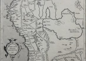
Peru – Peruani Regni descriptio
by Cornelius van WytflietPrice (without VAT, possibly to be added): €600,00 / $666,00 / £534,00 -
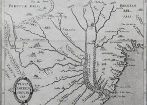
Rio de la Plata
by Cornelius van WytflietPrice (without VAT, possibly to be added): €500,00 / $555,00 / £445,00 -
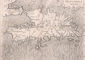
Hispaniola Insula
by Cornelius van WytflietFull of history
You may also be interested in:

Luxembourg, Duchy

San Adrian (Navarre) – La Sierra de Sant Adrian en Biscaia

Achaia, Attica and Gulf of Corinth

Map of the Moon – Tabula Selenographica in qua Lunarium
The unique and famous first comparative chart of the Moon (with double competing nomenclature) from which the names of many lunar features have been derived.
Cornelius Wytfliet (? – 1597)
Cornelius Wytfliet was a geographer from Leuven. After graduating Licentiate in Laws from the University of Leuven, Wytfliet moved to Brussels and became secretary to the Council of Brabant.
In 1597 he published the first atlas of America: the Descriptionis Ptolemaicae Augmentum (Augmentation to Ptolemy’s description). He named his work an augmentation to Ptolemy’s Geography because it covers the Americas, a part of the world unknown to Ptolemy. However, there is no other connection between the works of Ptolemy and Van Wytfliet. Dedicated to Philip III of Spain it is a history of the New World to date, recording its discovery, natural history, etc. It provides a history of exploration and the voyages of Christopher Columbus (1492-1502), John Cabot (1497-98), Sebastian Cabot (1526-28), Francisco Pizarro (1527-35), Giovanni de Verazzano (1524), Jacques Cartier (1540-42), and Martin Frobisher (1576-78). Most of Van Wytfliet’s maps are the first or among the earliest of specific regions of North and South America.
For the book, Wytfliet had engraved nineteen maps, one of the world and eighteen regional maps of the Americas. The book was an immediate success and ran to several editions.
Two editions of the Descriptionis Ptolemaicae were published et Leuven in 1597 and 1598. In 1603 appeared the first Douai edition with later editions with French text. The last edition was published in Arnhem in 1615.