


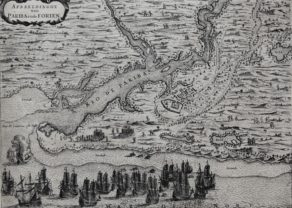
Praefecturae de Paraiba, et Rio Grande
Dutch Brazil
Detail
Date of first edition: 1662 (Blaeu, Atlas Maior)
Date of this edition: ca. 1720 (Covens Mortier)
Dimensions (not including margins): 41,56 x 53 cm
Dimensions (including margins): 54,5 x 67 cm
Condition: Excellent. A sharp impression with original color in the map and later color in the decorative elements, on a bright sheet with an “M” watermark. There are a few vertical printer’s creases, marginal soiling, and archivally repaired centerfold separations at top and bottom. Centre fold as published. Strong paper and wide margins.
Condition rating: A+
Verso: blank
Map reference: for Blaeu: Van der Krogt, II, 9850/3.2D
In stock
Paraiba or Pernambuco North
Superb map of the Brazilian coastline including the capitanias of Paraiba and Rio Grande. The map was drawn after actual surveys by Georg Markgraf, Elias Herckmanns and others, and was among the first maps of Brazil based on non-Portuguese data. The map is richly engraved with a huge scene of a procession of Tupinamba Indians carrying a Dutch flag, part of a sugar mill, and three major sea battles depicted in the sea. Further adorned with coats of arms, a compass rose and strapwork title cartouche. The series of maps of the capitanias of Brazil are unlike any other map in Blaeu’s atlases. Blaeu first issued this and its companion maps in 1647 for Gaspar Barleus’ Rerum per Octennium in Brasilia. They were also assembled into a large wall map, Brasilia qua parte paret Belgis; the places where the sheets overlapped are marked by faint lines at left. The maps then appeared in the Atlas Maior beginning in 1662, and were later sold to various publishers after Blaeu’s death. This map is the Covens-Mortier map of ca. 1720.
At bottom: three naval encounters between the Dutch and Portuguese fleets (parts II, II and IV); Part I of the battle is shown on the map of Pernambuco South.
Related items
-
Paraiba (Brazil)
by Isaac CommelinPrice (without VAT, possibly to be added): €350,00 / $388,50 / £311,50A Dutch intermezzo in Brazil
-
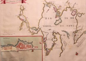
Bay of All Saints – Bahia de Todos los Sanctos
by Joan BlaeuPrice (without VAT, possibly to be added): €625,00 / $693,75 / £556,25A magnificent chart of Todos os Santos Bay in Brazil, with a detailed inset plan of Salvador and a scroll title cartouche.
You may also be interested in:

The Eastern Hemisphere – Hemisphaerium Orbis Antiqui

Veere – Vere

China, Tartary and Japan
The first modern map of China printed in Europe
