


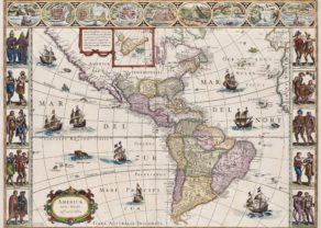
Nova Totius Terrarum Orbis Geographica ac Hydrographica
Magnificent carte-à-figures
The most beautiful atlas worldmap ever
Detail
Date of first edition: 1606
Date of this map: 1634/1635 (fourth state without a date)
Dimensions (not including margins): 41 x 54,5 cm
Dimensions (including margins): 49,5 x 58,5 cm
Condition: Very good. Sharp engraving on strong paper. Superb old coloring Wide margins. Centre fold as published (with reinforcement of centre fold at top and bottom margins). Back discretely reinforced with Japanese paper.
Condition rating: A
Verso: German
Map reference: Shirley (World), 255 State 4; Schilder 4, 10.4 & Schilder 6, 1.4; Van der Krogt 2, 0001:2A; Baynton-Williams New Worlds, p.59.
From: Atlas Novus. Van der Krogt2:131 or 2:132
In stock
Nova Totius Terrarum Orbis Geographica ac Hydrographica
Success of a map
While Blaeu was in the process of publishing his four-sheet wall map of the world on Mercator’s projection, a world map in folio size using the same projection was issued by his publishing house. For many years, this map remained in atlases published by the Blaeu family, in spite of the increasing geographical knowledge then available (only the discovery of the Strait of Le Maire was added to later states). Apparently, purchasers preferred a decorative map of the world to a map that provided up-to-date geographical knowledge. Eventually Joan Blaeu, in his Atlas Maior (1662-64), replaced the world map made by his father with a new map.
Title
The title in capitals runs along the upper edge within the map image. Because of the projection chosen, the areas north and south of the 50th degree of latitude are drawn in two hemispheres in the lower corners.
Dedication and States
The map’s dedication to the wealthy Amsterdam merchant and administrator Cornelis Pietersz Hooft (1547-1626) is now signed: Guilj. Blaeuw (in the first state, it was signed Gul. Iansonius 1606 = the old name of Willem Blaeu). The original 1606 state does not mention an engraver, but from the second state onward the name of Josua van den Ende appears on the map. It is probable that Van den Ende engraved only the geographic content, while someone else was responsible for the decoration.
The first state (1606) bears the name Gulielmus Ianssonius. The second state has the signature of the engraver Josua Van den Ende. The third state is with the Strait of Le Maire added (1618) and this fourth state is with the name of the publisher changed to ‘Blaeuw’.
The fourth state was included in Blaeu’s 1630 Appendix and in all of the Blaeu family’s atlases, except the Atlas maior.
Contents
The geographic content is identical to that of the 1606/07 wall map. Because of the smaller size of the folio map, fewer toponyms are given and the number of legends has also been reduced. The centre of North America is taken up by a large oval cartouche containing a Latin text, here in translation: ‘America. First discovered in A.D. 1492 by Christopher Colombus in the name of the king of Castille and given the name by Amerigo Vespucci in 1499’.
There is some confusion about the coastline of Northeast America, maybe due to Indianb reports on large bodies of water inland. California is correctly depicted an as a peninsula. The Le Maire Straits separating Tierra del Fuego from South America is introduced in this fourth state. A large terra australis is shown in the South. A note beside Nova Zembla states that it was reached by Barentsz in 1596. In the Far East Korea is an island.
Decorative borders
Blaeu’s world map is framed on all sides by decorative borders:
- Along the bottom are seven vignettes showing the seven ancient wonders of the world: the Hanging Gardens of Babylon, the Colossus over the harbour at Rhodos, the Pyramids, the Mausoleum of Halicarnassus at Caria, the Temple of Diane, the Statue of Jupiter, and the conical lighthouse of Alexandria.
- Along the top are allegorical representations of the sun, moon and the five known planets: Mercury, Venus, Mars, Jupiter and Saturn.
- On the left the four elements, and on the right the four seasons. Down the sides are, on the left, four panels illustrating the elements (Fire, Water, Air and Earth), and on the right, the four seasons.
The decorative borders of the world map were not derived from artists’ designs specially ordered by the publisher. On the contrary, Blaeu had a compilation made from various series of prints which had already been published by famous Dutch artists at the end of the sixteenth century. A balanced composition and elegant ornamentation make this world map one of the small masterpieces of the seventeenth century.
Related items
-

The Americas – Americae nova tabulae
by Willem and Joan BlaeuPrice (without VAT, possibly to be added): €7 500,00 / $8 325,00 / £6 675,00The most beautiful map of the continent: the absolutely top unique carte-à-figures … in time and place
-
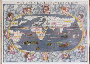
Typus Orbis Universalis 1550
by Sebastian MünsterPrice (without VAT, possibly to be added): €3 750,00 / $4 162,50 / £3 337,50
You may also be interested in:

Avignon
Papal city²

Portrait Abraham Ortelius, by Galle

Chart of the Gulf of Finland

Michiel de Ruyter, a super collection by Stoopendaal
Maybe the greatest admiral of all times