


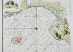
Southern Africa – Ptolemaic map
by
Lorenz Fries (after Martin Waldseemüller)
Discover the age of discoveries
Detail
Date of first edition: 1522
Date of this map: 1525
Dimensions (not including margins): 30 x 43 cm
Dimensions (including margins): 39,2 x 50 cm
Condition: very good. Sharp wood engraving printed on strong paper. Wide margins.
Condition rating: A
Verso: text in Latin: “Tab. Mo. Secundae Partis Aphricae
Map reference: Karrow 28/41; Moreland and Bannister, p.264
From: M. Waldseemüller – L. Fries, Opus Geographicae, Strasbourg, J. Grüninger, 1525
Price (without VAT, possibly to be added): €1 800,00 (FYI +/- $1 998,00 / £1 602,00)
Unless otherwise specifically stated on this map page, we charge the following expedition costs in euro (unfortunatelly, gone up with Covid, but still too low in reality!):
– Benelux: 40 euro
– Rest of Europe: 60 euro
– Rest of the World: 100 euro
In stock
Related items
-

Chart of Cape of Good Hope
by Johannes II van Keulen, Robert Laurie & James WittlePrice (without VAT, possibly to be added): €2 250,00 / $2 497,50 / £2 002,50Superb and scarce
-
Cape of Good Hope – Das Vorgebirg Der Guten Hofnung
by F.A. Scraembl, L.S. De la RochettePrice (without VAT, possibly to be added): €800,00 / $888,00 / £712,00Exceptional beauty
You may also be interested in:

Achaia, Attica and Gulf of Corinth
by
Johannes Janssonius
Price (without VAT, possibly to be added): €450,00 / $499,50 / £400,50

Lucca
by
Georg Braun and Frans Hogenberg
Price (without VAT, possibly to be added): €700,00 / $777,00 / £623,00

Map of the Moon – Tabula Selenographica in qua Lunarium
by
Johann Gabriel Doppelmayr
Price (without VAT, possibly to be added): €3 500,00 / $3 885,00 / £3 115,00
The unique and famous first comparative chart of the Moon (with double competing nomenclature) from which the names of many lunar features have been derived.

China, Tartary and Japan
by
Lorenz Fries (after Martin Waldseemüller)
Price (without VAT, possibly to be added): €4 000,00 / $4 440,00 / £3 560,00
The first modern map of China printed in Europe
Cope of Good Hope, Mountains of the Moon and Prester John: discover the Age of Discoveries
This map, based on the first map of Southern Africa by Martin Waldseemüller of 1513. Lorenz Fries published this version adding vignettes in the interior, including a dragon, serpents, an elephant and enthroned kings. Acknowledging the role played by the Portuguese in making this area known, the engraver has included a portrait of King Emmanuel riding a sea creature in the Indian Ocean.
Mountains of the Moon
The present map contains several elements that would appear odd to the modern eye. The Mountains of the Moon (Mone Lune), depicted at center below the Equator, were believed for centuries to be the source of the Nile River. Ptolemy’s Geographia tells the story Diogenes, a Greek trader and merchant traveling in East Africa around 110 AD. Diogenes supposedly discovered the Mountains of the Moon, whose snowmelt fed two great lakes, which in turn fed the Nile. While this map shows a second-century legend, the story was still a viable geographic theory in the sixteenth century. The Mountains of the Moon remained on maps long into the eighteenth century and beyond.
Rulers
The present map shows four different rulers. Near the Equator to the east, a crowned, bearded ruler is labled Quiola Regnum, likely referring to the area of Quiloa, now known as Kilwa Kisiwani, Tanzania. Kilwa Kisiwani was a major Swahili trading city that controlled Indian Ocean trade with Arabia, India, and China, especially between the thirteenth and sixteenth centuries, when Kilwa Kisiwani merchants traded gold and ivory for silver, perfumes, and Chinese porcelain. The city even minted its own currency between the eleventh and fourteenth centuries. After the Portuguese established a fort on Kilwa Kisiwani in the sixteenth century, the city began to decline.
Farther south near Mozambique (Moncabiqui), a crowned, bare-chested ruler is labeled Charagassa. Above the Tropic of Capricorn sits a third king, with robe and scepter, Hengi Zedaici.
Off the southeast coast, Emmanual, the most Christian King of Portugal (Manual I the Great and Fortunate, r. 1495-1521) sits astride a sea monster. This last scene is taken directly from Waldseemüller’s Carta Marina (1516).