


Dendermonde – Teneramonda vulgo Dendermonde
by
Joan Blaeu
ON HOLD
Detail
Date of first edition: 1641-44 (by A. Sanderus, Flandria Illustrata).
Date of this map: 1649
Dimensions (not including margins): 42 x 53 cm
Dimensions (with margins): 53, 3 x 63,3 cm
Condition: Excellent sharp copper engraving on strong paper with wide margins. Centre fold as published. Natural age-toning at edges of margins.
Condition rating: A+
Verso: text in Latin
Map references: Van der Krogt 4, 1027; Fauser, 2958
From: Novum Ac Magnum Theatrum Urbium Belgicae Regiae. Amsterdam, J. Blaeu
Price (without VAT, possibly to be added): €1 100,00 (FYI +/- $1 221,00 / £979,00)
Unless otherwise specifically stated on this map page, we charge the following expedition costs in euro (unfortunatelly, gone up with Covid, but still too low in reality!):
– Benelux: 40 euro
– Rest of Europe: 60 euro
– Rest of the World: 100 euro
In stock
Related items
You may also be interested in:

San Adrian (Navarre) – La Sierra de Sant Adrian en Biscaia
by
Georg Braun and Frans Hogenberg
Price (without VAT, possibly to be added): €700,00 / $777,00 / £623,00

Cuzco (Inca capital)
by
Giovanni Battista Ramusio
Price (without VAT, possibly to be added): €850,00 / $943,50 / £756,50
Rare first edition (block destroyed by fire)

Chart of the Gulf of Finland
by
Lucas Janszoon Waghenaer

Lisbon
by
Georg Braun and Frans Hogenberg
Price (without VAT, possibly to be added): €1 300,00 / $1 443,00 / £1 157,00
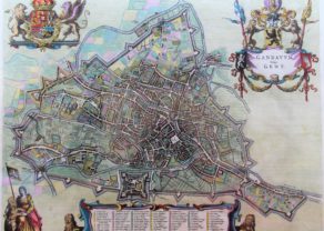
At the confluence of Scheldt and Dender
Grave sites go back to the Gallo-Roman period. A first fortress was built in the 10th century. Dendermonde received her city charter in 1233 and grew quickly after that thanks to a thriving cloth industry. The 16th century saw a decline in its fortunes. In 1572 Dendermonde was conquered by Willem van Oranje (William the Silent). The same year however Spanish troops under Duke Alexander Farnese of Parma, took over the city, looted and mostly destroyed it.
A decade later, the Spaniards built their own fortress (which is clearly visible) between the Dender and the Scheldt.
This superb map has a key to locations, decorated with 2 panoramic views and 4 coats-of-arms. It is dedicated to Gaspard Antoine d’Aubermont and eleven other magistrates of the town of Dendermonde by Vedastus du Plouich.