
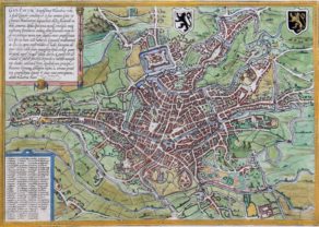
Gent – Plan de la ville et citadelle de Gand
by
Eugène-Henri Fricx
Main buildings put in relief
Detail
Date of first edition: 1712
Date of this map: 1712
Dimensions (not including margins): 60 x 46,8 cm
Dimensions (including margins): 61,6 x 48,8 cm
Condition: Excellent. Very sharp copper engraving on strong paper.
Condition rating: A+
Verso: blanc
From: Table des cartes des Pays Bas et des Frontià¨res de France, Avec un recueil des plans des villes, sià¨ges et battailles données entre les Hauts Alliés et la France. Bruxelles, H. Fricx, 1712
Price (without VAT, possibly to be added): €1 850,00 (FYI +/- $2 053,50 / £1 646,50)
Unless otherwise specifically stated on this map page, we charge the following expedition costs in euro (unfortunatelly, gone up with Covid, but still too low in reality!):
– Benelux: 40 euro
– Rest of Europe: 60 euro
– Rest of the World: 100 euro
In stock
Related items
You may also be interested in:

Cuzco (Inca capital)
by
Giovanni Battista Ramusio
Price (without VAT, possibly to be added): €850,00 / $943,50 / £756,50
Rare first edition (block destroyed by fire)

Portrait Abraham Ortelius, by Galle
by
Abraham Ortelius, Philip Galle
Price (without VAT, possibly to be added): €800,00 / $888,00 / £712,00

Lucca
by
Georg Braun and Frans Hogenberg
Price (without VAT, possibly to be added): €700,00 / $777,00 / £623,00

Scotland – Nova Scotia
by
Willem and Joan Blaeu
Price (without VAT, possibly to be added): €1 000,00 / $1 110,00 / £890,00
A nice map of Scotland
City under siege
The Siege of Ghent (18–30 December 1708) was the last operation of the 1708 campaign season during the War of the Spanish Succession. After successfully taking Lille shortly before, the Duke of Marlborough moved his forces onto the town of Ghent where after a 12-day siege the town’s governor, Count de la Motte, surrendered.
The defending French, believing that the fighting had concluded for the winter, had broken their army up after the loss of Lille, but Marlborough decided to make one more push in an effort to retake Ghent. His army arrived in the town on 18 December, where they found a defence consisting of around 18,000 with instructions to defend the town to the last.
As no relieving force appeared, de la Motte relinquished the town on that date to Marlborough.
One notices the large areas of inundation, as well as the three positions of attack. The map gives an overview of the main chronology of the siege. The main buildings are beautifully put in perspective.