


Zeeland – Zelandicarum insularum
Top left a sea monster with Neptune, holding the weapons of Zeeland
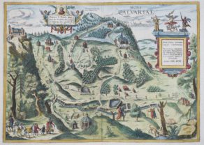
Detail
Date of first edition: 1570
Date of this map: most likely 1575 (5th state)
Dimensions (not including margins): 33,5 x 46,5 cm
Dimensions (including margins): 45 x 47,2 cm
Condition: very good. Sharp copper engraving printed on strong paper. Centre fold is as published. Original colouring. Wide margins. Some minor edges of margins are missing.
Condition rating: A
Verso: text in Latin with page signature 22 (only in Latin editions of 1573, 1574 and 1575)
Map reference: Van der Krogt IIIB, 3600:31, van den Broecke, 78; Blonk-van der Wijst (Zeeland), 2
From: Theatrum Orbis Terrarum
In stock
A success story
This map was very successful and published from 1570 to after 1612.
The map was continuously altered, since the waterfront changed rapidly. Ortelius published 9 states of Zeeland. This map is probably the 5th state, published in 1575.
The 4th state of 1574 ‘Ter neusen’ was added. We notice this name on this map.
In some of Latin editions of the 5th state (1574-1579) dots were added under the cartouche, which is not the case here. In some of these editions the arcing in the canvas of the ship was altered to lines going from top left to bottom left, which is so on this map (see detail picture).
The Latin versions of the 1574 and 1575 editions mention page 22 on the verso.
Related items
-
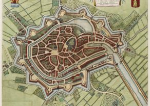
Middelburg – Middelburgum
by Joan BlaeuPrice (without VAT, possibly to be added): €900,00 / $999,00 / £801,00A jewel to visit
-
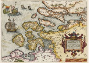
Zeeland
by Abraham OrteliusPrice (without VAT, possibly to be added): €1 000,00 / $1 110,00 / £890,00Top left a seamonster with Neptune, holding the weapons of Zeeland
Original title: Zelandicarum Insularum exactissima et nova descriptio, Auctore D. Iacobbo a Deventria
-

Veere – Vere
by Ludovico GuicciardiniPrice (without VAT, possibly to be added): €420,00 / $466,20 / £373,80 -
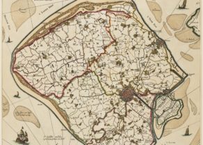
[Untitled] Walcheren in Zeeland
by Nicolaes VisscherPrice (without VAT, possibly to be added): €1 600,00 / $1 776,00 / £1 424,00Visit Walcheren!
-
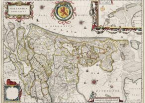
Holland – Hollandia Comitatus
by Willem and Joan BlaeuPrice (without VAT, possibly to be added): €1 350,00 / $1 498,50 / £1 201,50Orientated west to the top of the map. Inset of Frisian or Wadden islands
You may also be interested in:

Avignon
Papal city²
Kalwarya Zebrzydowska with Mons Calvariae (Krakow)

Bristol – Brightstowe, Vulgo; Quondam Venta, Florentissimum
