


Lancashire and the War of Roses
A unique map
Detail
Date of first edition: 1610
Date of this edition: 1611-1612
Dimensions (not including margins): 50,2 cm by 37,6 cm
Dimensions (including margins): 55 x 43 cm
Condition: very good. Sharp copper engraving printed on paper. Superb colouring.
Condition rating: A
From: Theatre of the Empire of Great Britaine, 1612
In stock
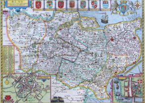
Lancashire by John Speed
This is a highly decorative and finely engraved 17th century map of Lancashire which was published in John Speed’s Theatre of the Empire of Great Britaine [London: J. Sudbury & G. Humble, 1627-1632 [John Dawson text]).
This is one of the most sought after Speed maps partly due to its left and rights panels displaying the portraits of all the kings of the houses of Lancaster and York, respectively. They played a key role in the War of Roses, which took place in the 2nd half of the 15th century. The house of York was represented by a white rose and the House of Lancaster, by a red rose.
The Kings on the map (in clockwise order)
1 Elisabeth (1533- 1603): reign 17 November 1558 – 24 March 1603. Known as Elisabeth I she was Queen of England and Ireland, after Henry VIII, in a golden age for England. Her parents were Henry VIII and Anna Boleyn. She was the last of the five monarchs of the House of Tudor. To be clear, she is Completely unrelated to the royalty which fought the War of Roses, decades before her birth. She was probably added as the sovereign ruling over England just before the making of this map.
2 Richard III: reign 26 June 1483 – 22 August 1485, House of York
3 Edward V: reign 9 April 1483 – 25 June 1483, House of York. Edward V, son of Edward IV, was never crowned, and his brief reign was dominated by the influence of his uncle and Lord Protector, the Duke of Gloucester, who deposed him to reign as Richard III on 26 June 1483.
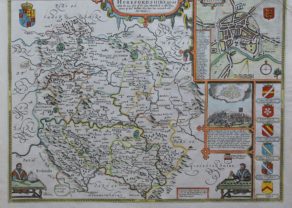
4 Edward IV (written IIII): reign 4 March 1461 – 3 October 1470, House of York. He fought and won the Battle at Mortimer’s Cross. John Speed’s map of Herefordshire shows an inset of that battle.
5 Henry IV (written IIII, also called Henry Bolingbroke): reign 20 September 1399 – 20 March 1413; grand-son of Edward III, House of Lancaster
6 Henry V: reign 21 March 1413 – 31 August 1422, child of Henry IV, House of Lancaster. He was victorious against the French in the Battle of Agincourt (1415)
7 Henry VI: reign 1422 – 1461 and 1470 – 1471, only child of Henry V. He finally defeated the House of York in the Battle of Tewkesbury on 4 May 1471. He founded Eton College, King’s College (Cambridge) and All Souls College (Oxford).
8 Henry VII, also Henry Tudor: a descendant of the Beauforts, a legitimized branch of the House of Lancaster.
Original title: The countie of Pallatine of Lancaster described and divided into hundrerds
The War of Roses in a synopsis:
Before the war
The House of Plantagenet, a royal House originating from the lands of Anjou in France held the English throne. Both the Houses of York and of Lancaster were cadet branches of the House of Plantagenet.
Please notice that at least partly, the Hundred Years’ War (1337 – 1453) took place simultaneously.
Initial Yorkist victory
- House of York reigns for most of the period
- Extinction of the House of Lancaster
- House of Tudor inherits the “Lancastrian claim”
- Final Yorkist defeat
- End of the Plantagenet dynasty
- Establishment of the Tudor dynasty
- End of the middle ages in England
- Strengthening of the English monarchy under the Tudors
- Dawn of the English Renaissance
The bird’s eye view plan of Lancaster, probably surveyed by Speed himself, is the earliest known of the city. On the reverse of the map there is a complete set of text briefly describing the history and topography of the county.
SIMPLY, A UNIQUE MAP!
Related items
-

Herefordshire
by John SpeedPrice (without VAT, possibly to be added): €500,00 / $555,00 / £445,00 -
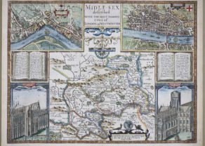
Middle-Sex described with the most famous cities of London and Westminster
by John SpeedPrice (without VAT, possibly to be added): €2 000,00 / $2 220,00 / £1 780,00 -
Kent – Kent with her Cities and Earles Described and Observed
by John SpeedPrice (without VAT, possibly to be added): €1 200,00 / $1 332,00 / £1 068,00
You may also be interested in:

The Eastern Hemisphere – Hemisphaerium Orbis Antiqui

Lucca

Lisbon

The atlas was completed in 1612; the maps are notable for the decorative elements included, evidence of Speed’s interest in antiquities and most have inset town-plans, the first series of printed town-plans of the British Isles, and were issued with descriptive English text printed on the verso. In the hands of different publishers, there were numerous editions to 1676 with text.