
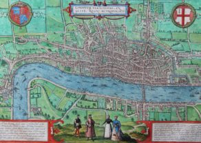
Middle-Sex described with the most famous cities of London and Westminster
by
John Speed
Detail
Date of first edition: 1610
Date of this map: after 1614
Dimensions (not including margins): 38 x 50,5 cm
Condition: Very good. Strong paper and wide margins. Centre fold as published
Condition rating: A+
Verso: text in English with table of the Hundreds
From: Theatre of the Empire of Great Britaine
Price (without VAT, possibly to be added): €2 000,00 (FYI +/- $2 220,00 / £1 780,00)
Unless otherwise specifically stated on this map page, we charge the following expedition costs in euro (unfortunatelly, gone up with Covid, but still too low in reality!):
– Benelux: 40 euro
– Rest of Europe: 60 euro
– Rest of the World: 100 euro
In stock
Related items
-
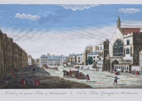
Westminster Palace – Vüe du Palais Episcopal de Westminster
by N.N.Price (without VAT, possibly to be added): €700,00 / $777,00 / £623,00Extremely rare
-
London
by Georg Braun and Frans HogenbergThe one and unique (oldest) map of London: exclusive
-
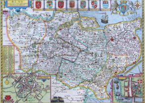
Kent – Kent with her Cities and Earles Described and Observed
by John SpeedPrice (without VAT, possibly to be added): €1 200,00 / $1 332,00 / £1 068,00 -
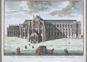
North Prospect of St. Peter’s Westminster
by J. ColePrice (without VAT, possibly to be added): €500,00 / $555,00 / £445,00Beautiful large view
You may also be interested in:

China, Tartary and Japan
by
Lorenz Fries (after Martin Waldseemüller)
Price (without VAT, possibly to be added): €4 000,00 / $4 440,00 / £3 560,00
The first modern map of China printed in Europe

Chester – Cestria vulgo Chester, Angliae Civitas
by
Georg Braun and Frans Hogenberg
Price (without VAT, possibly to be added): €900,00 / $999,00 / £801,00

Avignon
by
Georg Braun and Frans Hogenberg
Papal city²

Lisbon
by
Georg Braun and Frans Hogenberg
Price (without VAT, possibly to be added): €1 300,00 / $1 443,00 / £1 157,00
17th century Greater London in a nutshell
This superb “carte-à-figures” map shows the county of Middlesex; its verso contains a list of all its hundreds and a description of the cities (see note).
The historic county was located north of the River Thames, more or less from the Isle of Dogges to Stanes.
The rural area of the 16th century county have now fully been absorbed by the city expansion.
Following the River Thams stream upwards (from right to left) one notices the following villages and locations: Greeewich, Southwark, Lambeth, Battersey, Chelsey, Fullham, Richmond and far to the west (right) Windsore (including left bottom: Windsore Parke) and Eaton
Familiar metropolitan pop up: Totten Court, Kensington, Marybone, Paddington,Pancras, Hyde Park, S James, etc.
The map is embellished with insets of its two cities: Westminster and London (with its only bridge).
In the bottom corners both houses of God: St. Peter’s (Westmininster Abbey) and the former gothic cathedral of St. Paul’s before it was destroyed by the Great Fire of London in 1666.
For more information of the cities of Westminster and London: see the city plan by Braun & Hogenberg (item 40000).
John Speed
Speed (1552 – 1629) was born at Farndon in Cheshire, and as a young man joined his fathers tailoring business where he worked until middle age. He moved to London circa 1582 and it was while working there that his knowledge of history led him into learned circles. He joined the Society of Antiquaries where his interests came to the attention of Sir Fulke Greville, who’s patronage in 1598 allowed Speed to devote his whole attention to his interests. As a reward for his earlier efforts, Queen Elizabeth granted him the use of a room in the Custom House. It was with the encouragement of William Camden that he began his Historie of Great Britaine, which was published in 1611. Although Speed probably had access to historical sources that are now lost to us he certainly used the work of Saxton and Norden, his work as a historian is considered mediocre and secondary in importance to his map-making, of which his most important contribution is probably his town plans, many of which provide the first visual record of the British towns they depict.
Note: In 2000 Jeffrey John Speed published “Tudor Townscapes”, in which he provided zoomed-in pictures of the insets of the cites on the county maps with the original text of John Speed (ISBN 0906430 23 2).