


Leicester
Detail
Date of first edition: 1611 / 1676
Date of this edition: ca.1754
Dimensions (not including margins): 38,2 x 51,2 cm
Dimensions (with margins): 46,3 x 59,9 cm
Condition: Good. Sharp copper engraving. with wide .Centre fold as published. Superb light colouring. Slight age-toning.
Condition rating: A
Verso: blank
From: Theatre of the Empire of Great Britaine
Reference: Shirley (BL Atlases) T.SPE-1b.
In stock
Leicester
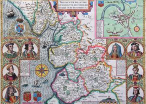
This classic decorative county map of Leicestershire is from John Speed’s important English atlas. It divides the county into its hundreds and shows towns and cities, parks, hills, rivers, and more. Besides presenting the most up-to-date information in his maps, Speed also included detailed city plans; this map includes a plan of Leicester complete with the city’s coat of arms and a key indicating places of interest. A vignette of the Battle of Bosworth, a battle fought on 22 August 1485 between the Houses of York and Lancaster during the Wars of the Roses, appears at bottom right with a note describing the fighting and how King Richard III was slain and then “layd all neked upon an horse, and trussed like a hogge.” The map also includes a title cartouche, the royal coat of arms of the United Kingdom and the arms of several important families of Leicestershire.
Leicerster is unique in the Midland’s of England, for its limited woodland areas and much reduced forests with few deer-parks, but a thriving farming community benefiting from the deforestation and enclosure of common land that had been going on since the Middle Ages. The county town of Leicester was by far the most important and housed the regional headquarters of the Duchy of Lancaster.
In popular imagination this importance was diminished by the notoriety of two figures buried there. Cardinal Wolsey was buried at Leicester Abbey in 1530, who died on his way to London to answer charges of treason. King Richard took an army to fight Henry of Richmond at Bosworth field III in 1485. His broken body had been brought back to the town “and without tears obscurely buried.”
Engraved by Jodocus Hondius. Published by Cluer Dicey.
Title: Leicester Both Countye and Citie Described, the Honorable Famylies That Have Had the Titles of Earls Thereof. With Other Accidents Therein Observed
John Speed
John Speed (1551 or ’52 – 28 July 1629) was the best known English mapmaker of the Stuart period. Speed came to mapmaking late in life, producing his first maps in the 1590s and entering the trade in earnest when he was almost 60 years old.
He was born in the Cheshire village of Farndon and from his youth pursued his father’s profession of tailoring. He later moved to London to continue this trade, though Speed’s real passions lay elsewhere, namely in the fields of antiquity and cartography. He joined the Society of Antiquaries where his enthusiasm soon attracted the attention of notables such as William Camden and Sir Fulke Greville. In 1596 Greville provided Speed with a full time allowance to write a ‘Historie of Great Britaine’. It was during this project that Speed decided to add a cartographic supplement to the work and it was from this that his famous atlas, ‘The Theatre of the Empire of Great Britaine’, was born.
Today his fame lies with two atlases The Theatre of the Empire of Great Britaine (first published 1612), and the Prospect of the Most Famous Parts of the World (1627). While The Theatre … started as solely a county atlas, it grew into an impressive world atlas with the inclusion of the Prospect in 1627. The plates for the atlas passed through many hands in the 17th century, and the book finally reached its apotheosis in 1676 when it was published by Thomas Bassett and Richard Chiswell, with a number of important maps added for the first time.
Related items
-
Lancashire and the War of Roses
by John SpeedPrice (without VAT, possibly to be added): €1 600,00 / $1 776,00 / £1 424,00A unique map
-
Kent – Kent with her Cities and Earles Described and Observed
by John SpeedPrice (without VAT, possibly to be added): €1 200,00 / $1 332,00 / £1 068,00 -
Middle-Sex described with the most famous cities of London and Westminster
by John SpeedPrice (without VAT, possibly to be added): €2 000,00 / $2 220,00 / £1 780,00
You may also be interested in:

Veere – Vere

Asia Secunda pars Terrae in Forma Pegasi

Avignon
Papal city²

Scotland – Nova Scotia
A nice map of Scotland