


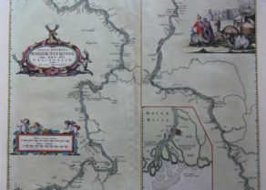
Russiae vulgo Moscovia pars australis. . . (South Russia)
Detail
Date of first map: 1640
Date of this map: 1644
Dimensions (without margins): 39 x 53 cm
Dimensions (including margins): 48,7 x 58 cm
Condition: Excellent copper engraving. Sharp printing. Centre fold as published. Wide margins. Small damage near to upper centerfold.
Condition rating: A+
Verso: text in Latin
Map reference: Van der Krogt 2, 1802:2; Taschen, Br. Hog. p.430
From: Theatrum Orbis Terrarum; Van der Krogt 2:202
In stock
Russia (South)
Centered on Moscow. The map shows the area between the Volga, the Don, the Sea of Azov and the Dnieper, with the city of Moscow approximately in the middle. Of interest is the canal plotted between the Volga and the Don, the “Fossa Kamouz” (at the lower right). This plan originated with Peter the Great, but was carried out as late as 1952.
Prepared by Isaac Massa, a Dutch mapmaker who traveled to Russia, returning to Holland in 1609, bringing with him a large amount of original cartographic manuscript material. These materials were the basic for a number of maps by both the Blaeu’s and Janssonius.
Blaeu has
Related items
You may also be interested in:

Scotland – Nova Scotia
A nice map of Scotland

Asia Secunda pars Terrae in Forma Pegasi

Lucca
