

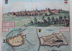
Saint Omer – Fanum S. Audomari vulgo S. Omer
by
Joan Blaeu
Detail
Date of the first edition: 1649
Date of this map: ca. 1660
Dimensions (without margins): 38 x 49 cm
Dimensions (including margins): 55,2 x 64,7 cm
Condition: Very good. Copper engraving on strong paper and wide margins. Centre fold as published Old colouring Small repair at top of top margin: not affecting map.
Condition rating: B
Verso: text in Latin
From: Novum Ac Magnum Theatrum Urbium Belgicae. (= “Stedeboeck”) Amsterdam, J. Blaeu, 1649
Price (without VAT, possibly to be added): €370,00 (FYI +/- $410,70 / £329,30)
Unless otherwise specifically stated on this map page, we charge the following expedition costs in euro (unfortunatelly, gone up with Covid, but still too low in reality!):
– Benelux: 40 euro
– Rest of Europe: 60 euro
– Rest of the World: 100 euro
In stock
Related items
-
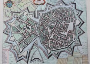
Bethune, Aire-sur-Lys and Thérouanne – Bethune, Aire Belgice Arien and Teroana
by Joan BlaeuPrice (without VAT, possibly to be added): €400,00 / $444,00 / £356,00 -
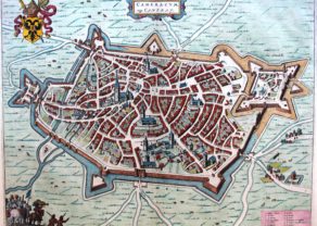
Cambrai – Cameracum vulgo Cambray
by Joan BlaeuPrice (without VAT, possibly to be added): €370,00 / $410,70 / £329,30 -
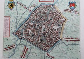
Arras – Atrebatum, Gallis ARRAS Belgice ATRECHT dictu
by Joan BlaeuPrice (without VAT, possibly to be added): €370,00 / $410,70 / £329,30 -
Valenciennes – Valentiana
by Joan BlaeuPrice (without VAT, possibly to be added): €380,00 / $421,80 / £338,20
You may also be interested in:

Jan Mayen – Insulae Johannis Mayen Cum universe situ Sinuum et Promontariorum
by
Joan Blaeu, Johannes Janssonius
Rare Spanish edition

Toledo (Castile) – Toletum
by
Georg Braun and Frans Hogenberg
Price (without VAT, possibly to be added): €1 500,00 / $1 665,00 / £1 335,00

Lucca
by
Georg Braun and Frans Hogenberg
Price (without VAT, possibly to be added): €700,00 / $777,00 / £623,00

Portrait Abraham Ortelius, by Galle
by
Philip Galle, Abraham Ortelius
Price (without VAT, possibly to be added): €800,00 / $888,00 / £712,00
Saint Omer
Saint-Omer first appeared in the writings during the 7th century under the name of Sithiu (Sithieu or Sitdiu), around the Saint-Bertin abbey founded on the initiative of Audomar, Odemaars or Omer). In 932 Arnulf of Flanders conquered the County of Artois and Saint-Omer (Sint-Omaars in Dutch) became part of the County of Flanders for the next three centuries
Later, Saint Omer was part of the Burgunidian Netherlands, Habsburg Netherands and later Spanish Netherlands.
The French made futile attempts against the town between 1551 and 1596. During the Thirty Years’ War, the French attacked in 1638 (under Cardinal Richelieu) and again in 1647. Finally in 1677, after a seventeen-day siege, Louis XIV forced the town to capitulate. The peace of Nijmegen signed in the fall of 1678 permanently confirmed the conquest and its annexation by France