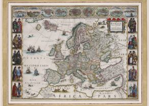
• Cart is empty
  • How To Order
  • FAQ
  • Sell
  • Terms and conditions
  • My Account
Podcast Facebook Instagram
  • Home
  • About Us
  • Mapmakers
  • Our Catalogue
  • Blog
  • Fairs & Seminars
  • Newsletter
  • Contact
  • How To Order
  • FAQ
  • Sell
  • Terms and conditions
  • My Account
Menu

Continent

Search by:
Mapmaker
  • Mapmaker
  • Region
  • Item number
  • Chart of the North Atlantic Ocean – Nieuwe Paskaert vande Geheele Oosterze en Noortze Schip-Vaart

    by Johannes van Keulen

    This item is sold

    A surprising and unexpected beauty!

    More info
  • Old double folio map of the Danube River by Willem and Joan Blaeu

    Danube River – Donau

    by Willem and Joan Blaeu
    Price: €1 500,00 / $1 605,00 / £1 335,00

    A rare map: from source to mouth

    More info
  • OLd and superb map of Europe (1631) by Henricus Hondiuss puslished in 1633

    Europe

    by Johannes Janssonius, Henricus Hondius

    This item is sold

    More info
  • Europe – Description novelle d’Evrope

    by Sebastian Münster

    This item is sold

    More info
  • Old carte-à-figures map of Europe by Willem and Joan Blaeu

    Europe – Europa

    by Willem and Joan Blaeu
    Price: €4 500,00 / $4 815,00 / £4 005,00

    Sheer beauty

    More info
  • One of the oldest maps of Europe by Hartman Schedel, 1493

    Europe [untitled]

    by Hartmann Schedel
    Price: €5 000,00 / $5 350,00 / £4 450,00

    Second oldest printed map of Europe

    More info
  • Old carte-à-figures map of Europe by John Speed

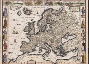
    Europe, carte-à-figures

    by John Speed
    Price: €2 700,00 / $2 889,00 / £2 403,00


    More info
  • Genealogy of European Royal families linked to France, Chatelain, 1707

    Genealogy tree of the Royalty in Europe

    by Henri Abraham Châtelain
    Price: €250,00 / $267,50 / £222,50
    More info
  • Northeast Atlantic Ocean – Septentrionalium Regionum descrip.

    by Abraham Ortelius
    Price: €2 900,00 / $3 103,00 / £2 581,00
    More info
  • Old antique maps of the world and the five continents by Abraham Ortelius (Theatrum Orbis Terrarum)

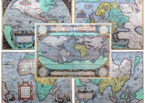
    Unique set of 5 maps (from the same French atlas, 1598): World and four Continents from the first modern atlas

    by Abraham Ortelius
    Price: €17 000,00 / $18 190,00 / £15 130,00
    More info
  • Zeus abducting Europa: Frontispiece for Europa in Atlas Maior

    by Joan Blaeu
    Price: €2 800,00 / $2 996,00 / £2 492,00

    Rare allegorical representation of Europe

    More info
Filter Products
  • Collections
  • World, Polars & Oceans
  • Africa
  • The Americas
    • Continent
    • North America
    • Central America & Caribbean
    • South America
  • Asia
    • Continent
    • Holy Land, Middle East & Iran
    • India & Shri Lanka
    • Southeast Asia
    • China
    • Japan & Korea
  • Oceania
  • Europe
    • Continent
    • Benelux
      • XVII Provinces
      • Belgium country
      • Belgium cities
      • Netherlands country
      • Netherlands cities
      • Luxembourg
    • France
    • Germany
    • Austria & Switzerland
    • British Isles
    • Scandinavia, Iceland & Baltics
    • Italy & Malta
    • Spain & Portugal
    • Central and East Europe
    • Southeast Europe
  • War maps
  • VOC-WIC
  • Celestial maps
  • Antiquity
  • Portraits & Titlepages
  • Optica prints
  • Curiosities
  • Atlases & Globes
  • Reference works & Facsimiles
  • Recent Additions

Navigation

  • Home
  • About Us
  • Mapmakers
  • Our Catalogue
  • Blog
  • Fairs & Seminars
  • Newsletter
  • Contact

Account

  • Login / My account

Contact

Edelweisslaan 13
3080 Tervuren (near Brussels)
Belgium
info@cartahistorica.com
+32 27 68 13 57
+32 496 58 81 10
BE0740984087
Facebook Instagram Podcast
©2019 - 2023 CartaHistorica. All Rights Reserved.
  • Sitemap
  • Privacy Policy
  • Cookie Policy

Website laten maken door Conversal