


Unique set of 5 maps (from the same French atlas, 1598): World and four Continents from the first modern atlas
Detail
Date of these maps: 1598
Condition: Good and sharp copper engraving. Original colours. Centre folds as published. Wide margins. General slight age-toning.
Condition rating: A
Verso: French
From: Theatrum Orbis Terrarum; van der Krogt, IIIB, 31:351
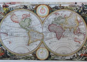
World
Dimensions (without margins): 36 x 48,8 cm
Dimensions (including margins): 46,8 x 58,6 cm
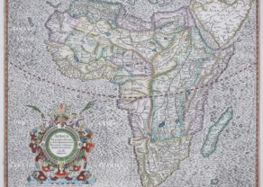
Africa
Dimensions (without margins): 46,5 x 58,9 cm
Dimensions (including margins): 37 x 49,9 cm
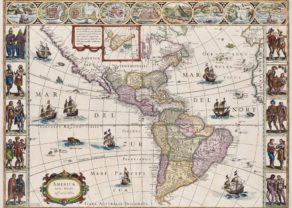
America
Dimensions (without margins): 35,5 x 48,5 cm
Dimensions (including margins): 46,7 x 58,6 cm
Asia
Dimensions (without margins): 37,4 x 48,3 cm
Dimensions (including margins): 46,9 x 59,3 cm
(small tear of 5 mm in left margin)
Europe
Dimensions (without margins): 34,2 x 46,5 cm
Dimensions (including margins): 46,6 x 58,8 cm
In stock
Ortelius: his World – Continents maps
A Unique set from the same French atlas 1598
Early matching set of maps of the World and Continents, from Abraham Ortelius’ Theatrum Orbis Terrarum, the first modern World Atlas, 1598.
Ortelius’ Theatrum was perhaps the single most influential set of maps published in the 16th Century. First issued in 1570 and expanded over the next forty two years to this final Vrients edition of Ortelius’ masterwork, the Theatrum revolutionized the presentation of maps to an increasingly educated classes of Renaissance Europe and became the standard from which most cartographic works of the period were copied.
Each of the five maps offered here were the standards for their time, drawn from the most important wall maps produced by Mercator, Ortelius and other leading European mapmakers and represented the completion of the shift of importance from the Italian mapmakers of the mid-16th Century (the so-called Lafreri School of mapmakers), to the Low Countries, marking the beginning of the Golden Age of Dutch Cartography.
-
Typus Orbis Terrarum
This map was made by Francois De Belleforest and it is based upon the cartography of Gastaldi and Gerard Mercator’s highly important 1569 wall map. The title is given in large letters above the image and below, is a quotation from Cicero in Latin: “What do human affairs signify when one considers the vastness of the world and all eternity?”
The map includes a Northwest Passage and Northeast Passage and a massive Southern Continent which is attached to New Guinea. It also mentions place names reported by Marco Polo. A curious projection of Japan and Southeast Asia is shown. In comparison to his previous versions of the World, South America has lost its curious bulge. The projection of America is based upon Mercator’s Wall map of 1569, as is most of the other cartographic detail. Twol sea monsters and a sailing ship appear in the Pacific and Indian Oceans.
Quite a few new place names appearing along the North American west coast were provided to Ortelius by Hakluyt on the basis of recent explorations.
-
Africae Tabula Nova
:“The map of Africa was, apparently, one of the few for which Ortelius) was responsible, as he gives no source, but it has been pointed out that there is some similarity between this map and the copperplate engraved maps of Forlani and Gastald (the latter’s 8-sheet map of 1564).” (Norwich)
The map is significant for several reasons, including its place in the history of cartography of the African continent, its depiction of Central Africa and its rivers, and its inclusion in the first modern atlas.
The main branch of the Nile is sourced from two lakes at roughly the same latitude. The larger of these rivers is also the source for the Zuama and Zaire Rivers. The former, which is also a name for the Zambezi River, branches into the Spiritu Sant, which is supposedly the Limpopo River. All the rivers are amalgamated here, reflecting the common Medieval belief that most continents had a central lake which gave rise to the largest rivers of the landmass. Farther north, the Niger River rises from Lake Niger.
Ortelius here also includes a large central lake, called Cafates. He rejected the name of Zaire-Zembere used by Gastaldi. To the east and just slightly north is another, smaller lake. Rivers from the north of both lakes wend northward and join to form the Nile. The Zaire (Congo) flows from the northeast of Lake Cafates, while the Zuama (Zambezi) exits at the south of the lake. It branches into the Spiritu Sant, or the Limpopo. Thus, one lake gives rise to four of the largest rivers in Africa.
It is embellished with a ferocious sea battle southeast of Madagascar and several sea monsters in the Atlantic.
The drawing of the far eastern coast of Brazil, shown as well below the Equator.
-
Americae sive Novi Orbis, Nova Descriptio
This map is probably the single most widely viewed and copied maps of America published in the 16th Century.
“One of the most famous and easily recognized maps of America, and one that is both functional as well as decorative”.(Burden)
Ortelius depicts the discoveries of several people on this map. The general shape of the continent is derived from Gerard Mercator’s great twenty-one sheet world map of 1569. The two of them had a close relationship and shared their knowledge openly with each other. It is recorded that they travelled together through France in 1560. A strategically placed cartouche hides a complete lack of knowledge of the southern waters of the Pacific. Once through the Strait of Magellan, the voyager’s sea route took him on an almost direct course for the East Indies. No sight had been made of a vast continent, but conventional wisdom had it that there had to be as much land in the southern hemisphere as in the northern. This was not entirely dispelled until the second voyage of the remarkable Captain James Cook in 1772-75. The west coast of North America is shown too far west, as was common at the time. There is no new nomenclature shown.
On this plate, Ortelius inserted additional information of Terra Australis and the Solomon Islands (discovered in 1568 by Pedro Sarmiento and Alvaro de Mendoza). He also added locations and notes on the west coast of the Americas, probably after Hakluyt.
This is the third of three copperplates that Ortelius used to depict the American continent.
The first plate of 1570 had by now developed a number of cracks. It is almost identical to the earlier plate with the exception of the following: The largest ship in the Pacific is sailing westwards, and the Equator is shown with no graduations between the longitudinal marks.
1579 plate: The largest ship in the Pacific is shown sailing eastwards, and there now appear graduations along the equatorial line.
1587 plate: The bulge to the south-western coast of South America is removed.
-
Asiae Nova Descriptio
This map is the atlas version of Ortelius’ own wall map of Asia, published in 1567, derived from Gastaldi and Albufeda.
It has a marvelous incorrect projection of Japan and Southeast Asia, a very distinct Northeast Passage, and it includes sailing ships and other embellishments.
-
Europae
The relatively modest cartouche shows partially covered and apparently distraught Europe sitting on the back of a placid Zeus as bull, both gazing toward Europe. Since 1584 this map had replaced the first plate. The only differences being a cursive writing of Africae Pars and a sharper engraving of this map.
There were many sources fo his maps: This map is based on Gerard Mercator’s 1554 map of Europe. Greenland is derived from Mercator’s 1569 world map. Both these maps were used for depicting Iceland. Great Britain after Mercator’s 1564 Great Britain map.
Scandinavia goes back to Olaus Magnus’ 1539 Scandinavia map and Russia is based on Jenkinson’s 1562 Russia map. The South Eastern part of this map based on Gastaldi’s first map of Asia of 1559 and parts of the North African coast are based on Gastaldi’s Africa map of 1564.
Overall a very attractive uniform set of Ortelius’ maps of the World & Continents, from his Theatrum Orbis Terrarum.
Rarity
While the individual maps of the world and each of the continents appear regularly on the market, matching sets from the same edition of the atlas are relatively scarce.
Related items
-
Africa – Africa Ex magna orbis terrae descriptione
by Henricus Hondius, Gerard Mercator jr., grandson of Gerard MercatorPrice (without VAT, possibly to be added): €1 800,00 / $1 998,00 / £1 602,00 -
World – Orbis Terrarum Tabula Recens Emendata et in Lucem Edita
by Nicolaes VisscherPrice (without VAT, possibly to be added): €2 500,00 / $2 775,00 / £2 225,00First state world map, with California depicted as peninsula
-

Asia Secunda pars Terrae in Forma Pegasi
by Heinrich Bünting -
The Americas – Americae nova tabulae
by Willem and Joan BlaeuPrice (without VAT, possibly to be added): €7 500,00 / $8 325,00 / £6 675,00The most beautiful map of the continent: the absolutely top unique carte-à-figures … in time and place
You may also be interested in:

Map of the Moon – Tabula Selenographica in qua Lunarium
The unique and famous first comparative chart of the Moon (with double competing nomenclature) from which the names of many lunar features have been derived.

[Untitled] Japan
Very rare: oldest map of Japan, and … based on Polo’s description

Cuzco (Inca capital)
Rare first edition (block destroyed by fire)
