


Spieghel der Zeevaerdt by Waghenaer, facsimile
Detail
Waghenaer’s Spieghel der Zeevaerdt
Full title: Spieghel der Zeevaerdt, van de navigatie der Westersche Zee, Innehoudende alle de Custe va Vranckrijck, Spaignen en ‘t principaelste deel van Engelandt. Printed in Leyden Leyden by Christoffel Plantijn, Anno MDLXXXIV.
Facsimile edition: Lausanne, Sequoia SA, 1964
Unpaged hardback (leatherette) in slip-case with booklet
40 x 30 cm
Weight 3,3 kg. Because of the weight special transport conditions have to be agreed. The general pricing on costs (mentioned below) is not applicable
Language: facsimile in Dutch, but booklet (72 pages) is in French
This item is sold
Spieghel der Zeevaerdt
His first publication, Spieghel der zeevaerdt (“Mariner’s mirror”), appeared in 1584. This chart-book combined an atlas of nautical charts and sailing directions with instructions for navigation on the western and north-western coastal waters of Europe. It was the first of its kind in the history of nautical cartography, and was an immediate success. A second part was published the next year and was reprinted several times, and translated into English, German, Latin, and French.
Enjoy some pictures of this fine decorative work:
1 Facsimile book
2 Facsimile book open
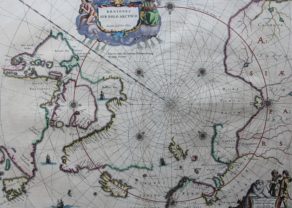
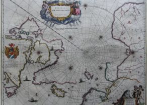
3 Europe
2 Andalusia with Cadiz
3 Algarve
3 Portugal with Porto
4 Normandy and Channel Islands
5 Flanders (original map soon to be added)
6 Zeeland with 4 coats of arms
7 Wadden
8 Jutland
9 From Gdansk (Danzig) to Kaliningrad (Königsberg)
11 Scotland with Edinburg
12 South England between Wight and Dover
13 England with Land’s End
14 Title page
15 Book in slip-case
16-19 Introductory booklet (72 pages) in French
Related items
You may also be interested in:

Algiers – Algerii Saracenaorum Urbis Fortissimae…

Lisbon

Michiel de Ruyter, a super collection by Stoopendaal
Maybe the greatest admiral of all times

Lucas Janszoon Waghenaer
Naturally, navigation guides already existed. The Arte de Navegar of the Spaniard Pedro De Medina dates from 1545. In 1573, the Portuguese Pedro Nunes published a large study on navigation in De arte atque ratione navigandi. The oldest production of “nautical charts” in the Low Countries goes back to the work of Jan Seversz (1532), Jan Jacobsz (1541), Cornelis Anthonisz (1544) and Jan Ewoutsz (1558), among others. In fact, these are not nautical charts, as known today, but reading charts with coastal profiles, a manual for the skittish coaster with written instructions. The reading map describes the coasts with landmarks such as harbors, beacons and estuaries and shows tide tables, depth soundings and sometimes soil characteristics.
Scientific and systematic maritime cartography started in the 1580s with the European coastal maps of Lucas Janszoon Waghenaer and Aelbert Haeyen. Waghenaer became the pivotal figure between the shifting of cartography from the south to the north.
For three reasons he may be considered as symbol of the 17th century Dutch mapmaking schoofor the first time a very important cartographer came from the north (without any ascension from the south); moreover, he lived and worked in Enkhuizen and not in Amsterdam.
Secondly, he was already active in the 16th century.
Finally, he published the first maritime atlas albeit limited to the European coasts. His charts are still characterized with coastal profiles and with a very nice maintained calligraphy.
Also Willem Barentsz, who had sailed to Spain and the Mediterranean in his younger years, produced (in collaboration with Plancius) a Nieuwe Beschryvinghe ende Caert-Boeck van de Midlantsche Zee, which is published in 1595. The engraving was by Kaerius. The work is considered as a addendum to the coastal maps of Waghenaer and is published until 1626 with language versions in Dutch and French.